Belvedere, London
| Belvedere | |
 All Saints Church |
|
 Village streetscene with the Congregational Church |
|

Belvedere
|
|
| OS grid reference | TQ495785 |
|---|---|
| London borough | Bexley |
| Ceremonial county | Greater London |
| Region | London |
| Country | England |
| Sovereign state | United Kingdom |
| Post town | BELVEDERE |
| Postcode district | DA17 |
| Dialling code | 020 [n 1] |
| 01322 | |
| Police | Metropolitan |
| Fire | London |
| Ambulance | London |
| EU Parliament | London |
| UK Parliament | Erith & Thamesmead |
| London Assembly | Bexley and Bromley |
Lua error in package.lua at line 80: module 'strict' not found.

Belvedere /ˈbɛlvədɪər/ is a district of south east London, England within the London Borough of Bexley. It is located south east of Thamesmead and 12 miles (19 km) ESE of Charing Cross.
Contents
History
The area which is today known as Belvedere was for centuries part of Lesness Heath,[1] the eastern parts of a narrow high ridge which stretches from the area of Lesnes Abbey to Erith. The northern stretch is industrial and environmental and was common meadow. In 1847 this largely uncultivated, wooded estate, almost undivided was given by operation of the will of last Lord Saye and Sele to his cousin Sir Culling Eardley, who built properties in Belvedere until his death in 1863. Eardley constructed a large wooden tower (see Belvedere (structure)) on the heath to gain views over his estate to the river Thames, giving the area its name from the Italian "beautiful view". The name can also be applied today, as the ridge of the area, and parts of its southern uplands, have commanding views towards Canary Wharf and Central London.[n 2]
Eardley was persuaded to allow the construction on his property, of a Dissenters' chapel, which was built so that the original wooden belvedere became its tower. In order that the public were able to attend this chapel, he constructed paths to it across Lesness Heath. Eardley had finished in 1861, after nearly 8 years of building, his chapel, now All Saints' Church, after the earlier chapel with belvedere burned down on the same site.[2] At the same time Eardley constructed Villa Houses and reinforced the heath path to become Erith Road. The village of Belvedere soon grew up along the path which became Nuxley Road as Eardley gradually sold off the land.
- 1900 to date
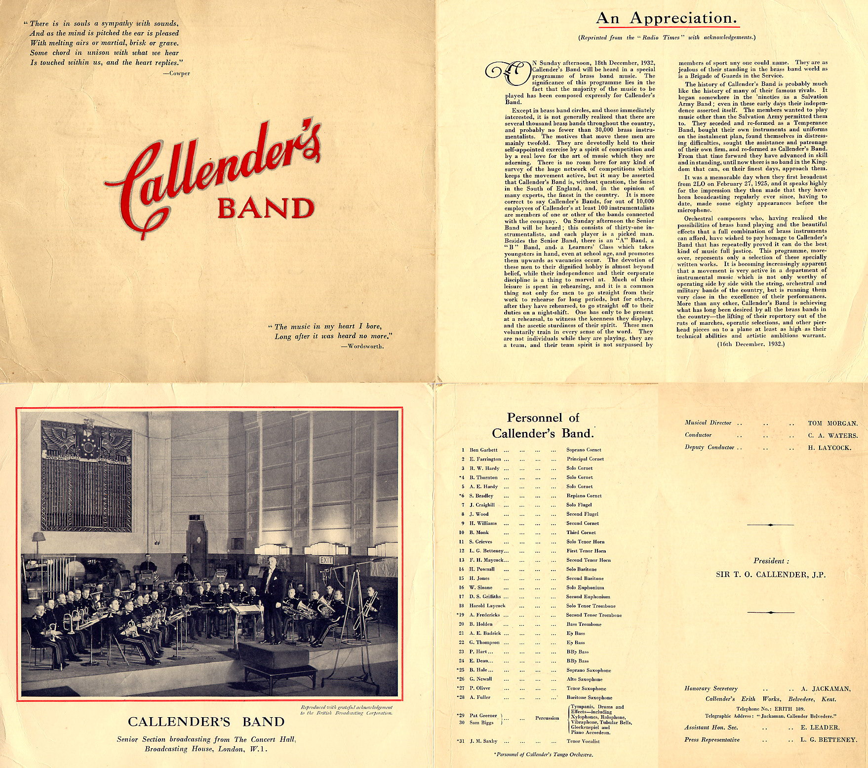
Belvedere was in Kent (and postally remains so) and formed part of the Municipal Borough of Erith before 1965 and development took place before the Second World War, with significant reconstruction after the Blitz. Despite this, Upper Belvedere and The Village still retains much of its Victorian and Edwardian charm and character. Between 1898 and 1961 Callender's Cable Works, at the Erith Works, Belvedere, was patron to Callender's Cableworks Band, an amateur brass band made up of employees of the company. The band was a prolific broadcaster on BBC Radio in the 1920s and 1930s.[3]
Subdistricts
Within the ward are:
- Erith Marshes/Crossness Nature Reserve
- Abbey Wood, Bostall Heath and Woods, Lesnes Abbey, Thamesmead, and West Heath.
Landmarks
Upper Belvedere features a fine church and some fine Victorian & Edwardian brick villas. It has a number of fine pubs, restaurants and retail outlets: The Eardley Arms on Woolwich Road, The Vic on Victoria Street, The Royal Standard in the heart of the village and The Fox in Belvedere village.[4] Upper Belvedere is also home to a large park and a library that was in danger of being shut down due to the government's cuts. Fortunately closure threats have been averted thanks to the efforts of the local community. A new 'Splash Park' (opened in 2005) was a welcomed addition to the village, having been developed on the site of the old Victorian paddling pool. The splash park retains some of the original paddling pool structures. The water feature is now under threat of removal by the Council, (it is out of action for the 2015/16 season, and the maintenance budget has been drastically cut). The local community is campaigning for the water feature to be reopened.[5]
Lower Belvedere is smaller and more industrial and has a Methodist chapel, a Sikh Temple and borders to its north the high technology sludge, methane incinerator, a small industrial park, large waste incinerator and Joseph Bazalgette's Crossness Sewage Treatment Works and is closer to the railway station than Upper Belvedere. Lower Belvedere is also the location of the Belvedere Community Forum,[6] which runs and meets at Belvedere Community Centre.[7]
The Grade II Listed Bexley College was designed in 1906 by W Egerton in the Queen Anne style and is on residential Erith Road on the last part of the ridge, in the east of the district on the border of Erith.[8]
Places of worship
- Free Grace Baptist Church, Nuxley Road, Belvedere
- Belvedere Congregational Church, Picardy Road
- Guru Nanak Darbar, Sikh Temple, Mitchell Close
Politics
Councillors for the Belvedere Ward of Bexley London Borough Council are Daniel Francis (Labour), Gill MacDonald (Labour) and Seán Newman (Labour). Belvedere lies within the Erith and Thamesmead constituency (MP Teresa Pearce, Labour), and is in the Bexley and Bromley London Assembly constituency, represented by James Cleverly (Conservative).
Education
- For education in Belvedere, London see the main London Borough of Bexley article
Sport
Erith and Belvedere Football Club recently moved to Welling in a ground-sharing arrangement. Belvedere Football Club play at Memorial Sports Ground, Woolwich Road, Abbey Wood and compete in the Kent County League Division One (West).
Bexleyheath and Belvedere Hockey Club are based in Welling, but play some home matches at Erith School.[9]
Transport
Rail
Belvedere railway station, opened in 1859, is in Lower Belvedere and is served by the North Kent Line which runs from London Cannon Street to Dartford/Gravesend/Gillingham (Kent). Belvedere also benefits from the DLR connection at nearby Woolwich, and will benefit further with the arrival of the long awaited 'Crossrail' extension in neighbouring Abbey Wood in 2017.
Buses
Belvedere is served by several Transport for London Bus services connecting it with areas including Thamesmead, Erith, Bexleyheath, Woolwich and Sidcup.
Green Chain Walk
The Green Chain Walk is largely east-west route along the northern slopes of the ridge, stretching from Plumstead Common to Erith, it provides a shortcut to the Thames Path - to which it is linked in three locations.
Motoring
Driving test statistics from the DVSA for the year 2013-14 showed that Belvedere test centre had the lowest pass rate in Great Britain.[10]
The proposed Belvedere Crossing across the River Thames would be either a bridge or tunnel between Belvedere and Rainham. [11]
Nearest places
See also
Notes and references
- Notes
- References
- ↑ Lua error in package.lua at line 80: module 'strict' not found.
- ↑ All Saints' Church - Grade II Lua error in package.lua at line 80: module 'strict' not found.
- ↑ Callender's Band performance programme or handout leaflet, 16 Dec 1932
- ↑ Erroneously called by some 'Nuxley Village' because the main road is 'Nuxley Road'. Like most roads in the area Nuxley Road is named with reference to Sir Culling Eardley who lived at Belvedere Manor (subsequently the site of the Royal Alfred Seaman's Home). Nuxley was the name of a village that used to exist on his Bedwell estate, which was cleared in the 1700s land enclosures. The Road in Belvedere is named after the Hertfordshire village, not the village itself.
- ↑ https://www.facebook.com/Saveoursplashpark?fref=ts
- ↑ http://www.bexley.gov.uk/index.aspx?articleid=13233
- ↑ http://belvederecommunitycentre.org.uk/
- ↑ Lua error in package.lua at line 80: module 'strict' not found.
- ↑ Lua error in package.lua at line 80: module 'strict' not found.
- ↑ Lua error in package.lua at line 80: module 'strict' not found.
- ↑ https://consultations.tfl.gov.uk/rivercrossings/east-of-silvertown?cid=east-london-crossings
External links
- www.belvedereuk.info - A comprehensive local history site being developed
- Belvedere Football Club
- Lesnes Abbey Conservation Volunteers (LACV)
- Belvedere Parcel Delivery Company
