File:CIAIranKarteOelGas.jpg

Summary
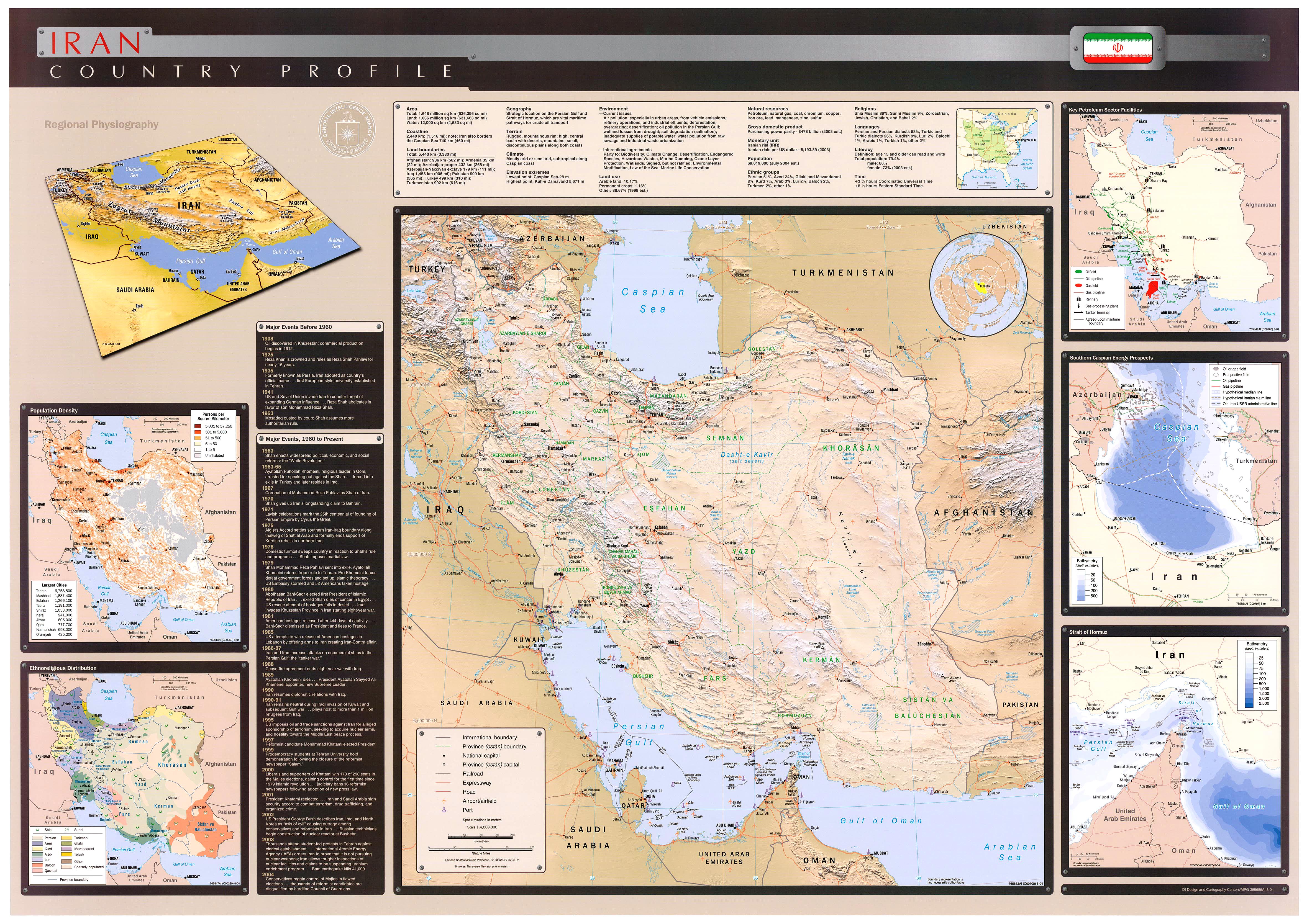
Key Petroleum Sector facilities (2004)
Iran (Wall Map) 2004 "Iran Country Profile" Iran map with insets: Population Density, <a href="https://en.wikipedia.org/wiki/Ethnoreligious_group" class="extiw" title="en:Ethnoreligious group">Ethnoreligious</a> Distribution, Key Petroleum Sector Facilities, Southern Caspian Energy Prospects and Strait Of Hormuz (2.5M) (source: CIA map)
<a rel="nofollow" class="external free" href="http://www.lib.utexas.edu/maps/middle_east_and_asia/iran_country_profile_2004.jpg">http://www.lib.utexas.edu/maps/middle_east_and_asia/iran_country_profile_2004.jpg</a>
Licensing
Lua error in package.lua at line 80: module 'strict' not found.
File history
Click on a date/time to view the file as it appeared at that time.
| Date/Time | Thumbnail | Dimensions | User | Comment | |
|---|---|---|---|---|---|
| current | 09:15, 3 January 2017 | | 687 × 705 (51 KB) | 127.0.0.1 (talk) | Key Petroleum Sector facilities (2004) <p>Iran (Wall Map) 2004 "Iran Country Profile" Iran map with insets: Population Density, <a href="https://en.wikipedia.org/wiki/Ethnoreligious_group" class="extiw" title="en:Ethnoreligious group">Ethnoreligious</a> Distribution, Key Petroleum Sector Facilities, Southern Caspian Energy Prospects and Strait Of Hormuz (2.5M) (source: CIA map) </p> <a rel="nofollow" class="external free" href="http://www.lib.utexas.edu/maps/middle_east_and_asia/iran_country_profile_2004.jpg">http://www.lib.utexas.edu/maps/middle_east_and_asia/iran_country_profile_2004.jpg</a> |
- You cannot overwrite this file.
File usage
The following 39 pages link to this file:
- Anglo-Persian Oil Company
- Asaluyeh
- Atomic Energy Organization of Iran
- Bushehr Nuclear Power Plant
- Darkhovin Nuclear Power Plant
- Dauletabad–Sarakhs–Khangiran pipeline
- Economy of Iran
- Energy in Iran
- Foreign direct investment in Iran
- Gas Exporting Countries Forum
- Iran
- Iranian Offshore Engineering and Construction Company
- Iranian oil bourse
- Iranian subsidy reform plan
- Iran–Armenia gas pipeline
- Iran–Pakistan gas pipeline
- Joint Comprehensive Plan of Action
- Korpeje–Kordkuy pipeline
- List of dams and reservoirs in Iran
- List of power stations in Iran
- Marun petrochemical complex
- Ministry of Energy (Iran)
- Ministry of Petroleum (Iran)
- Nabucco pipeline
- National Iranian Gas Company
- National Iranian Oil Refining and Distribution Company
- National Petrochemical Company
- Natural gas reserves in Iran
- Nuclear facilities in Iran
- Nuclear program of Iran
- Oil reserves in Iran
- Persian Pipeline
- Petroleum industry in Iran
- Sanctions against Iran
- South Pars / North Dome Gas-Condensate field
- Strait of Hormuz
- Tabriz–Ankara pipeline
- Wind power in Iran
- Template:Energy in Iran