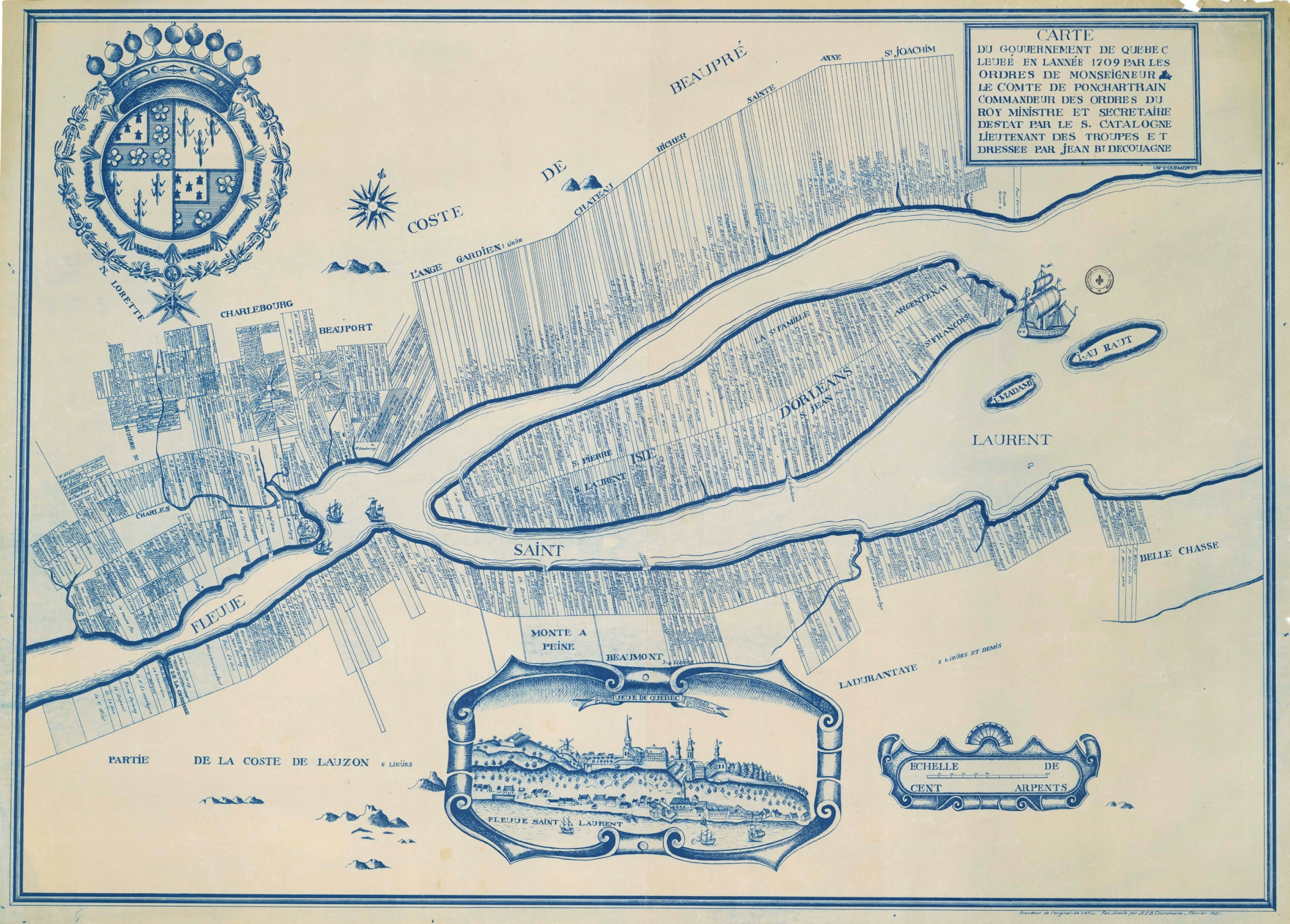
L'Île-d'Orléans Regional County Municipality
From Infogalactic: the planetary knowledge core
(Redirected from L'Île-d'Orleans Regional County Municipality, Quebec)
| L'Île-d'Orléans | |
|---|---|
| Regional county municipality | |
 |
|
| Coordinates: Lua error in package.lua at line 80: module 'strict' not found.[1] | |
| Country | |
| Province | |
| Region | Capitale-Nationale |
| Effective | January 1, 1982 |
| County seat | Sainte-Famille |
| Government[2] | |
| • Type | Prefecture |
| • Prefect | Jean-Pierre Turcotte |
| Area[2][3] | |
| • Total | 268.50 km2 (103.67 sq mi) |
| • Land | 192.81 km2 (74.44 sq mi) |
| Population (2011)[3] | |
| • Total | 6,711 |
| • Density | 34.8/km2 (90/sq mi) |
| • Pop 2006-2011 | |
| • Dwellings | 3,470 |
| Time zone | EST (UTC−5) |
| • Summer (DST) | EDT (UTC−4) |
| Area code(s) | 418 and 581 |
| Website | www |
L'Île-d'Orléans is a regional county municipality in central Quebec, Canada, in the Capitale-Nationale region. Its seat is Sainte-Famille. The population in the 2011 census was 6,711 persons.
The RCM consists solely of the Île d'Orléans, an island in the Saint Lawrence River just east of Quebec City. It is the smallest RCM in Quebec in terms of land area (though not in total area including water).
Contents
Subdivisions
There are 6 subdivisions within the RCM:[2]
|
|
|
Demographics
Population
| Historical Census Data - L'Île-d'Orléans Regional County Municipality, Quebec[6] | ||||||||||||||||||||||||||
|---|---|---|---|---|---|---|---|---|---|---|---|---|---|---|---|---|---|---|---|---|---|---|---|---|---|---|
|
|
|
||||||||||||||||||||||||
Language
| Canada Census Mother Tongue - L'Île-d'Orléans Regional County Municipality, Quebec[6] | ||||||||||||||||||
|---|---|---|---|---|---|---|---|---|---|---|---|---|---|---|---|---|---|---|
| Census | Total |
French
|
English
|
French & English
|
Other
|
|||||||||||||
| Year | Responses | Count | Trend | Pop % | Count | Trend | Pop % | Count | Trend | Pop % | Count | Trend | Pop % | |||||
|
2011
|
6,610
|
6,480 | 98.03% | 75 | 1.13% | 10 | 0.15% | 45 | 0.68% | |||||||||
|
2006
|
6,780
|
6,540 | 96.46% | 80 | 1.18% | 55 | 0.81% | 105 | 1.55% | |||||||||
|
2001
|
6,705
|
6,645 | 99.11% | 25 | 0.37% | 20 | 0.30% | 15 | 0.22% | |||||||||
|
1996
|
6,780
|
6,695 | n/a | 98.75% | 40 | n/a | 0.59% | 20 | n/a | 0.29% | 25 | n/a | 0.37% | |||||
Transportation
Access Routes
Highways and numbered routes that run through the municipality, including external routes that start or finish at the county border:[7]
|
|
|
|
See also
References
- ↑ Reference number 141064 of the Commission de toponymie du Québec (French)
- ↑ 2.0 2.1 2.2 Geographic code 200 in the official Répertoire des municipalités (French)
- ↑ 3.0 3.1 3.2 Lua error in package.lua at line 80: module 'strict' not found. Cite error: Invalid
<ref>tag; name "cp2011" defined multiple times with different content Cite error: Invalid<ref>tag; name "cp2011" defined multiple times with different content - ↑ Lua error in package.lua at line 80: module 'strict' not found.
- ↑ Lua error in package.lua at line 80: module 'strict' not found.
- ↑ 6.0 6.1 Statistics Canada: 1996, 2001, 2006, 2011 census
- ↑ Official Transport Quebec Road Map
External links
 |
Saint Lawrence River La Côte-de-Beaupré RCM |
|
||
| Saint Lawrence River Quebec TE |
||||
|
||||
| Saint Lawrence River Lévis TE |
Saint Lawrence River Bellechasse RCM |
Saint Lawrence River Montmagny RCM |
| Regional county municipalities and equivalent territories |
|
|---|---|
| Municipalities | |