Caesarea
<templatestyles src="Module:Hatnote/styles.css"></templatestyles>
| Caesarea <templatestyles src="Script/styles_hebrew.css" />קֵיסָרְיָה قيسارية |
|
|---|---|
| Hebrew transcription(s) | |
| • standard | Keisarya |
| • official | Qesarya |

Modern town of Caesarea
|
|

Caesarea
|
|
| Coordinates: Lua error in package.lua at line 80: module 'strict' not found. | |
| District | Haifa |
| Area | 35,000 dunams (35 km2 or 14 sq mi) |
| Population (2006) | 4,400 |
| • Density | 130/km2 (330/sq mi) |
Caesarea (Hebrew: <templatestyles src="Script/styles_hebrew.css" />קֵיסָרְיָה, Kesariya; Arabic: قيسارية, Qaysaria; Greek: Καισάρεια) is a town in Israel located mid-way between Tel Aviv and Haifa (45 km), on the Israeli coastal plain near the city of Hadera. Modern Caesarea as of December 2007 had a population of 4,500 people.[1] It is the only Israeli locality managed by a private organization, the Caesarea Development Corporation,[2] and also one of the most populous localities not recognized as a local council. It lies under the jurisdiction of the Hof HaCarmel Regional Council.
The town was built by Herod the Great about 25–13 BCE as the port city Caesarea Maritima. It served as an administrative center of Judaea Province of the Roman Empire, and later the capital of the Byzantine Palaestina Prima province during the classic period. Following the Muslim conquest in the 7th century, in which it was the last city to fall to the Arabs, the city had an Arab majority until Crusader conquest. It was abandoned after the Mamluk conquest.[3] It was re-populated in 1884 by Bosniak immigrants, who settled in a small fishing village.[3] In 1940, kibbutz Sdot Yam was established next to the village. In February 1948 the village was conquered by a Palmach unit commanded by Yitzhak Rabin, its people already having fled following an attack by the Stern Gang. In 1952, a Jewish town of Caesarea was established near the ruins of the old city, which were made into the national park of Caesarea Maritima.
Contents
History
<templatestyles src="Module:Hatnote/styles.css"></templatestyles>
Antiquity

Caesarea is believed to have been built on the ruins of Stratonospyrgos (Straton's Tower), founded by Straton I of Sidon. It was likely an agricultural storehouse station in its earliest configuration.[6] In 90 BCE, Alexander Jannaeus captured Straton's Tower as part of his policy of developing the shipbuilding industry and enlarging the Hasmonean kingdom. Straton's Tower remained a Jewish settlement for two more generations, until the area became dominated by the Romans in 63 BCE, when they declared it an autonomous city. The pagan city underwent vast changes under Herod the Great, who renamed it Caesarea in honor of the Roman emperor, Caesar Augustus.
In 22 BCE, Herod began construction of a deep sea harbor and built storerooms, markets, wide roads, baths, temples to Rome and Augustus, and imposing public buildings.[7] Every five years the city hosted major sports competitions, gladiator games, and theatrical productions in its theatre overlooking the Mediterranean Sea.
Caesarea also flourished during the Byzantine period. In the 3rd century, Jewish sages exempted the city from Jewish law, or Halakha, as by this time the majority of the inhabitants were non-Jewish.[8] The city was chiefly a commercial centre relying on trade.
Middle Ages
| Qisarya | |
|---|---|

The Bosnian Mosque at Qisarya
|
|
| Arabic | قيسارية |
| Also spelled | Arab al-Bara, Barrat Qisarya |
| Subdistrict | Haifa |
| Population | 960[9][10] (1945) |
| Area | 31,786[9] dunams |
| Date of depopulation | February, 1948[11] |
| Cause(s) of depopulation | Expulsion by Yishuv forces |
| Current localities | Caesarea |
.jpg)
The Muslim historian al-Biladhuri (d. 892) mentions Kaisariyyah/Cæsarea as one of ten towns in Jund Filastin (military district of Palestine) conquered by the Muslim Rashidun army under 'Amr ibn al-'As's leadership during the 630s.[12][13][14]
The area was only seriously farmed during the Rashidun Caliphate period, apparently until the Crusader conquest in the eleventh century.[8] Over time, the farms were buried under the sands shifting along the shores of the Mediterranean.
Nasir-i-Khusraw noted a "beautiful Friday Mosque" in Caesarea in year 1047 C.E., "so situated that in its court you may sit and enjoy the view of all that is passing on the sea."[15] This was converted into the church of St. Peter in Crusader times. A wall which may belong to this building has been identified in modern times.[16][17]

Khusraw further noted that it "is a fine city, with running waters, and palm-gardens, and orange and citron trees. Its walls are strong, and it has an iron gate. There are fountains that gush out within the city."[15]
The Arab geographer Yaqut, writing in the 1220s, named Kaisariyyah as one of the principal towns in Filastin.[18]
Caesarea was under Crusader control between 1101-87 and again between 1191 and 1265.[19]
In 1251, Louis IX of France fortified the city, ordering the construction of high walls (parts of which are still standing) and a deep moat. However, strong walls could not keep out the sultan Baybars, who ordered his troops to scale the walls in several places simultaneously, enabling them to penetrate the city. During the Mamluk era, the ruins of Caesarea Maritima by the Crusader fortress near Caesarea on the Mediterranean coast lay uninhabited.[citation needed]
Al-Dimashqi, writing around 1300, noted that Kaisariyyah belonged to the Kingdom of Ghazza.[20]
Ottoman period
In 1664, a settlement is mentioned consisting of 100 Moroccan families, and 7–8 Jewish ones.[21] In the 18th century it again declined.[22]
In 1806, the German explorer Seetzen saw "Káisserérie" as a ruin occupied by some poor fishermen and their families.[23]
In 1870, Victor Guérin visited.[24]
Caesarea lay in ruins until the nineteenth century, when the village of Qisarya (Arabic: قيسارية, the Arabic name for Caesarea) was established in 1884 by Bushnaks (Bosniaks) – immigrants from Bosnia, who built a small fishing village on the ruins of the Crusader fortress on the coast.[25][26]
Petersen, visiting the place in 1992, writes that the nineteenth-century houses were built in blocks, generally one story high (with the exception of the house of the governor.) Some houses on the western side of the village, near the sea, have survived. There were a number of mosques in the village in the nineteenth century, but only one ("The Bosnian mosque") has survived. This mosque, located at the southern end of the city, next to the harbour, is described as a simple stone building with a red-tiled roof and a cylindrical minaret. It was used (in 1992) as a restaurant and as a gift shop.[17]
British Mandate
In the 1922 census of Palestine, conducted by the British Mandate authorities, Caesarea had a population of 346; 288 Muslims, 32 Christian and 26 Jews,[27] where the Christians were 6 Orthodox, 3 Syrian Orthodox, 3 Roman Catholics, 4 Melkites, 2 Syrian Catholics and 14 Maronite.[28] The population had increased in the 1931 census to 706; 19 Christians, 4 Druse and 683 Muslims, in a total of 143 houses.[29]
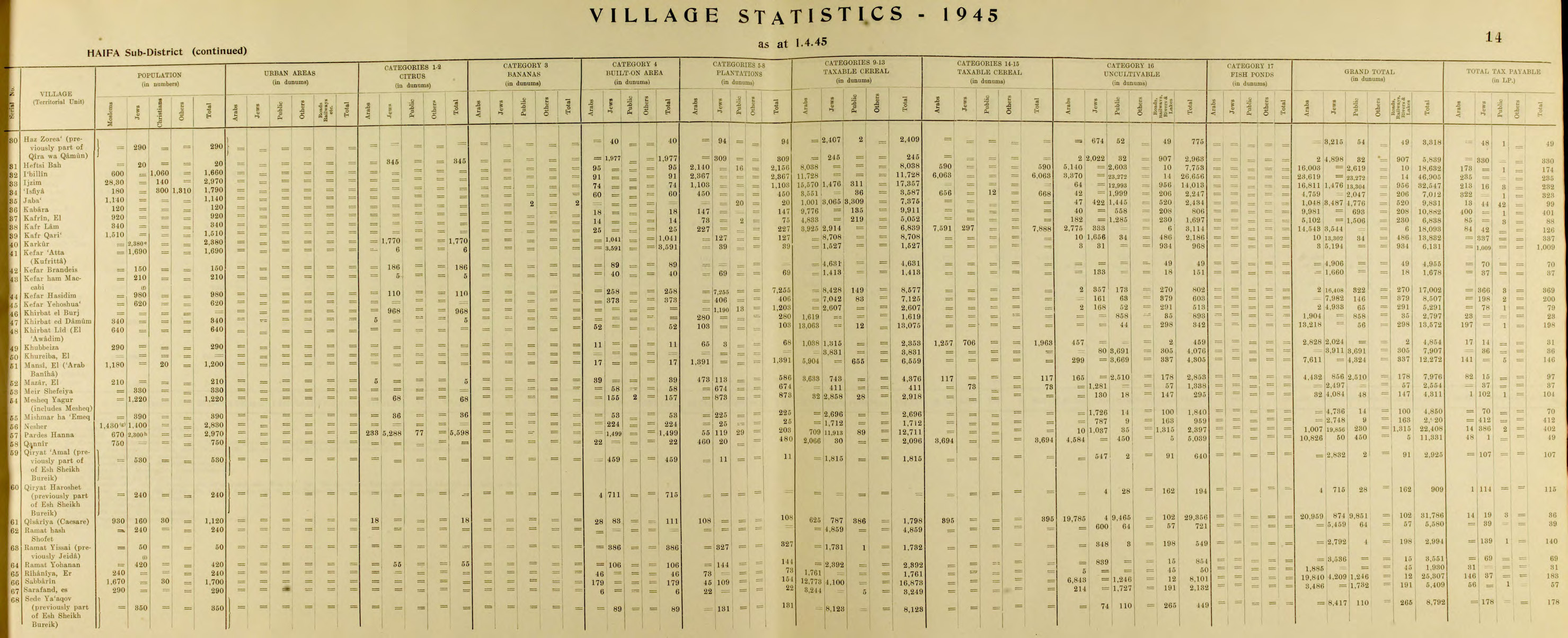
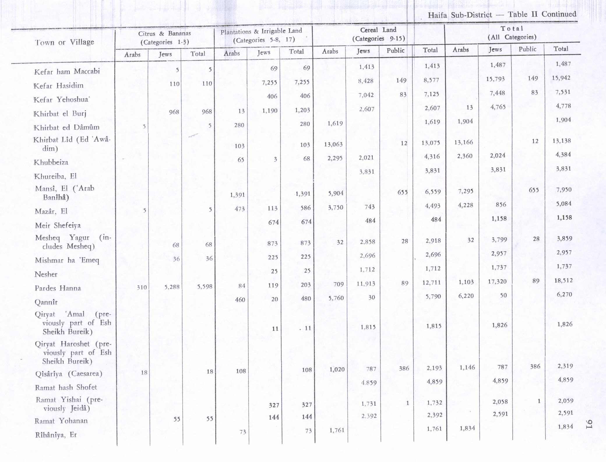
The Jewish kibbutz of Sdot Yam was established 1 kilometre (0.62 mi) south of the Arab town in 1940. The Arab village declined in economic importance and many of Qisarya's Arab inhabitants left in the mid-1940s, when the British extended the Palestine Railways which bypassed the shallow-draft port. Qisarya had a population of 960 in 1945,[10] with Qisarya's population composition 930 Muslims and 30 Christians in 1945.[10] In 1944/45 a total of 18 dunums of Arab village land was used for citrus and bananas, 1,020 dunums were used for cereals, while 108 dunums were irrigated or used for orchards,[30][31] while 111 dunams were built-up (urban) land.[32]
The Civil War began on 30 November 1947. In December 1947 a village notable Tawfiq Kadkuda approached local Jews in an effort to establish a non-belligerency agreement.[33] The 31 January 1948 Stern Gang attack on a bus leaving Qisarya, killed 2 and injuring 6 people, precipitated an evacuation of most of the population, who fled to nearby al-Tantura.[34] The Haganah then occupied the village because the land was owned by Palestine Jewish Colonization Association, but, fearing that the British would force them to leave, decided to demolish the houses.[34] This was done on February 19–20, after the remaining residents were expelled and the houses were looted.[34] According to Benny Morris, the expulsion of the population had more to do with illegal Jewish immigration than the ongoing civil war.[35] In the same month the 'Arab al Sufsafi and Saidun Bedouin, who inhabited the dunes between Qisarya and Pardes left the area.[36] Palestinian historian Walid Khalidi described the village remains in 1992: "Most of the houses have been demolished. The site has been excavated in recent years, largely by Italian, American, and Israeli teams, and turned into a tourist area. Most of the few remaining houses are now restaurants, and the village mosque has been converted into a bar."[37]
State of Israel

After the establishment of the state, the Rothschild family agreed to transfer most of its land holdings to the new state. A different arrangement was reached for the 35,000 dunams of land the family owned in and around modern Caesarea: after turning over the land to the state, it was leased back (for a period of 200 years) to a new charitable foundation. In his will, Edmond James de Rothschild stipulated that this foundation would further education, arts and culture, and welfare in Israel. The Caesarea Edmond Benjamin de Rothschild Foundation was formed and run based on the funds generated by the sale of Caesarea land which the Foundation is responsible for maintaining. The Foundation is owned half by the Rothschild Family, and half by the State of Israel.[citation needed]
The Foundation established the Caesarea Edmond Benjamin de Rothschild Development Corporation Ltd. (CDC) in 1952 to act as its operations arm. The company transfers all profits from the development of Caesarea to the Foundation, which in turn contributes to organizations that advance higher education and culture across Israel.[citation needed]
Geography

Caesarea is located on the Israeli coastal plain, the historic land bridge between Europe, Asia and Africa approximately halfway between the major cities of Tel Aviv 45 kilometers (28 mi) and Haifa 45 kilometers (28 mi). Caesarea is situated approximately 5 kilometers (3 mi) northwest of the city of Hadera, and is bordered to the east by the Caesarea Industrial Zone and the city of Or Akiva. Directly to the north of Caesarea is the town of Jisr az-Zarqa.
Caesarea is divided into a number of residential zones, known as clusters. The most recent[citation needed] of these to be constructed is Cluster 13, which, like all the clusters, is given a name: in this case, "The Golf Cluster", due to its close proximity to the Caesarea Golf Course. The golfcourse was built upon an ancient Arab town on the site of a loosely grouped Egyptian and subsequently Greek structures, with archaeological ruins.[citation needed] These neighborhoods are affluent, although they vary significantly in terms of average plot size.[citation needed]
Demographics

As of December 2007, Caesarea had a population of approximately 4,500.[1] This represented a 2.5% growth rate over the past year, in part due to the development of new homes in the new Cluster 13. Estimations show that as of mid-2008, the population had risen by about 100 to 4,600.[1]
Caesarea Foundation

The Caesarea Edmond Benjamin de Rothschild Development Corporation (Hebrew: החברה לפיתוח קיסריה אדמונד בנימין דה רוטשילד) is the operational arm of the Caesarea Edmond Benjamin de Rothschild Foundation, whose goal is to establish a unique community that combines quality of life and safeguarding the environment with advanced industry and tourism.[citation needed]
Today, the Chairman of the Caesarea Foundation and the CDC is Baron Benjamin de Rothschild, the great grandson of the Baron Edmond de Rothschild. Caesarea remains today the only locality in Israel managed by a private organization rather than a municipal government. As well as carrying out municipal services, the Caesarea Development Corporation markets plots for real-estate development, manages the nearby industrial park, and runs the Caesarea's golf course and country club, Israel's only 18-hole golf course.[citation needed]
Modern Caesarea is one of Israel's most upscale residential communities. The Baron de Rothschild still maintains a home in Caesarea, as do many business tycoons from Israel and abroad.[citation needed]
Economy
Caesarea is a suburban settlement with a number of residents commuting to work in Tel Aviv or Haifa.[citation needed]
The Caesarea Business Park is on the fringe of the city. In the park are approximately 170 companies. They employ about 5,500 people. Industry in the park includes distribution and high technology services.[citation needed]
The residential neighborhoods have a shopping concourse with a newsagent, supermarket, optician, and bank. There are a number of restaurants and cafes scattered across the town, with a number within the ancient port.[citation needed]
Infrastructure
Roads
 Beyond the eastern boundary of the residential area of Caesarea is Highway 2, Israel's main highway linking Tel Aviv to Haifa. Caesarea is linked to the road by the Caesarea Interchange in the south, and Or Akiva Interchange in the center.
 Slightly further to the east lies Highway 4, providing more local links to Hadera, Binyamina, Zichron Yaakov, and the moshavim and kibbutzim of Emek Hefer.
 Highway 65 starts at the Caesarea Interchange and runs westwards into the Galilee and the cities of Pardes Hanna-Karkur, Umm al-Fahm, and Afula.
Rail
Caesarea shares a railway station with nearby Pardes Hanna-Karkur which is situated in the Caesarea Industrial Zone and is served by the suburban line between Binyamina and Tel Aviv with two trains per hour. The Binyamina Railway Station, a major regional transfer station, is also located nearby.[citation needed]
Culture

The Roman theatre, located at the site, often hosts concerts by major Israeli and international artists, such as Shlomo Artzi, Yehudit Ravitz, Mashina, Deep Purple, Björk and others. Furthermore, the port has in recent years become home to the annual Caesarea Jazz Festival which offers three evenings of top-class jazz performances by leading international artists. Furthermore, the Ralli Museum in Caesarea houses a large collection of South American art and several Salvador Dalí originals.[38]
Sports
.jpg)
Caesarea is the location of the country's only full-size golf course.[39] The idea for the Caesarea Golf and Country Club originated after James de Rothschild was reminded by the dunes surrounding Caesarea of Scotland's sandy links golf courses. Upon his death, the James de Rothschild Foundation established the course. In 1958 a Golf Club Committee was established, and a course was built. American professional golfer Herman Barron, the first Jewish golfer to win a PGA Tour event, helped develop the course.[40] It was officially opened in 1961 by Abba Eban. The Caesarea Golf Club has hosted international golf competitions every four years in the Maccabiah Games. The course was redesigned and rebuilt by golf course designer Pete Dye in 2007–2009. [41]
Notable residents
- Saint Albina
- Laetitia Beck, golfer
- Ezer Weizman, seventh President of Israel
- Keren Ann, pop singer
- Arcadi Gaydamak, Russian-Israeli businessman
- Eitan Wertheimer, industrialist
- Benjamin Netanyahu, politician and the current Prime Minister of Israel
- Avraham Yosef Schapira, politician and a businessman
References
- ↑ 1.0 1.1 1.2 Lua error in package.lua at line 80: module 'strict' not found.
- ↑ About the CDC
- ↑ 3.0 3.1 Lua error in package.lua at line 80: module 'strict' not found.
- ↑ Barber, 2004, p. 168
- ↑ Mariti, 1792, p. 399
- ↑ Lua error in package.lua at line 80: module 'strict' not found.
- ↑ Crossan, 1999, p. 232
- ↑ 8.0 8.1 Safrai, 1994, p. 374
- ↑ 9.0 9.1 Government of Palestine, Department of Statistics. Village Statistics, April, 1945. Quoted in Hadawi, 1970, p. 49
- ↑ 10.0 10.1 10.2 Department of Statistics, 1945, p. 14
- ↑ Morris, 2004, p. xviii, village #177. Also gives the cause for depopulation
- ↑ The conquered towns included "Ghazzah (Gaza), Sabastiyah (Samaria), Nabulus (Shechem), Cæsarea, Ludd (Lydda), Yubna, Amwas (Emmaus), Yafa (Joppa), Rafah, and Bayt Jibrin. (Bil. 138), quoted in le Strange, 1890, p.28
- ↑ Al-Baladhuri, 1916, pp. 216-219
- ↑ Meyers, 1999, p. 380
- ↑ 15.0 15.1 le Strange, 1890, p. 474
- ↑ Pringle, 1993, p. 170 -72
- ↑ 17.0 17.1 Petersen, 2001, p.129-130
- ↑ le Strange, 1890, p. 29
- ↑ Pringle, 1997, pp. 43-45
- ↑ le Strange, 1890, p 41
- ↑ Roger, 1664; cited in Ringel 1975, 174; cited in Petersen, 2001, p.129
- ↑ Petersen, 2001, p129
- ↑ Seetzen, 1854, vol 2, pp. 72–73. Alt: [1]
- ↑ Guérin, 1875, pp. 321–339
- ↑ Oliphant, 1887, p. 182
- ↑ Lua error in package.lua at line 80: module 'strict' not found.
- ↑ Barron, 1923, Table XI, Sub-district of Haifa, p. 34
- ↑ Barron, 1923, Table XVI, p. 49
- ↑ Mills, 1932, p. 95
- ↑ Khalidi, 1992, p. 183
- ↑ Government of Palestine, Department of Statistics. Village Statistics, April, 1945. Quoted in Hadawi, 1970, p. 91
- ↑ Government of Palestine, Department of Statistics. Village Statistics, April, 1945. Quoted in Hadawi, 1970, p. 141
- ↑ Morris, 2004, p. 92
- ↑ 34.0 34.1 34.2 Morris, 2004, p. 130
- ↑ Morris, 2008, pp. 94–95.
- ↑ Morris, 2004, p. 129
- ↑ Khalidi, 1992, p.184
- ↑ Lua error in package.lua at line 80: module 'strict' not found.
- ↑ Golf Digest magazine, May 2010
- ↑ Herman Barron bio page on International Jewish Sports Hall of Fame website
- ↑ http://www.caesarea.com/pages_e/640.aspx Country Club – About
Bibliography
- Abu Shama (d. 1267) (1969): Livre des deux jardins ("The Book of Two Gardens"). Recueil des Historiens des Croisades, Cited in Petersen (2001).
- Lua error in package.lua at line 80: module 'strict' not found.
- Lua error in package.lua at line 80: module 'strict' not found.
- Lua error in package.lua at line 80: module 'strict' not found.
- Lua error in package.lua at line 80: module 'strict' not found.
- Lua error in package.lua at line 80: module 'strict' not found.
- Lua error in package.lua at line 80: module 'strict' not found. (pp. 12-29, 34)
- Lua error in package.lua at line 80: module 'strict' not found.
- Lua error in package.lua at line 80: module 'strict' not found.
- Lua error in package.lua at line 80: module 'strict' not found.
- Lua error in package.lua at line 80: module 'strict' not found.
- Lua error in package.lua at line 80: module 'strict' not found.
- Lua error in package.lua at line 80: module 'strict' not found.
- Lua error in package.lua at line 80: module 'strict' not found.
- Lua error in package.lua at line 80: module 'strict' not found. (p. 396 ff)
- Lua error in package.lua at line 80: module 'strict' not found.
- Lua error in package.lua at line 80: module 'strict' not found.
- Lua error in package.lua at line 80: module 'strict' not found.
- Lua error in package.lua at line 80: module 'strict' not found.
- Lua error in package.lua at line 80: module 'strict' not found.
- Lua error in package.lua at line 80: module 'strict' not found.
- Lua error in package.lua at line 80: module 'strict' not found.
- Lua error in package.lua at line 80: module 'strict' not found.
- Lua error in package.lua at line 80: module 'strict' not found.
- Lua error in package.lua at line 80: module 'strict' not found.
- Lua error in package.lua at line 80: module 'strict' not found.
- Lua error in package.lua at line 80: module 'strict' not found.
- Lua error in package.lua at line 80: module 'strict' not found. (p. 44)
- Lua error in package.lua at line 80: module 'strict' not found.
- Lua error in package.lua at line 80: module 'strict' not found.
- Lua error in package.lua at line 80: module 'strict' not found.
- Lua error in package.lua at line 80: module 'strict' not found.
- Lua error in package.lua at line 80: module 'strict' not found.(Sharon, 1999, pp. 252)
- Lua error in package.lua at line 80: module 'strict' not found.
- al-'Ulaymi Sauvaire (editor) (1876): Histoire de Jérusalem et d'Hébron depuis Abraham jusqu'à la fin du XVe siècle de J.-C. : fragments de la Chronique de Moudjir-ed-dyn p. 80–81
External links
| Wikimedia Commons has media related to Caesarea. |
- Places To Visit in Caesarea (English)
- Welcome To Qisarya
- Survey of Western Palestine Map 7: IAA, Wikimedia commons
- Caesarea Development Corporation
- Jacques Neguer, Byzantine villa:Conservation of the "gold table" and preparation for its display, Israel Antiquities Authority Site - Conservation Department
- Use dmy dates from July 2013
- Articles containing Arabic-language text
- Articles containing Hebrew-language text
- Articles containing Greek-language text
- Articles with unsourced statements from September 2015
- Articles with unsourced statements from July 2012
- Articles with unsourced statements from July 2013
- Commons category link is defined as the pagename
- Hof HaCarmel Regional Council
- Caesarea (Israel)
- Planned communities
- 1st-century BC establishments in Judea
- Populated places established in the 1st century BC
- District of Haifa
- Arab villages depopulated prior to the 1948 Arab–Israeli War
- Populated places in Haifa District
- Ancient Jewish settlements of Judaea
- 1884 establishments in the Ottoman Empire