Denny Regrade, Seattle
<templatestyles src="Module:Hatnote/styles.css"></templatestyles>


The Denny Regrade is a neighborhood in Seattle, Washington, USA, that stretches north of the central business district to the grounds of Seattle Center. Its generally flat terrain was originally a steep hill, taken down as part of a mammoth construction project in the first decades of the 20th century.[1] The neighborhood is named after that project. The northeastern portion of the Denny Regrade is sometimes known as the Denny Triangle, a term that has gained currency as this neighborhood has seen increasing development in the first decades of the 21st Century.
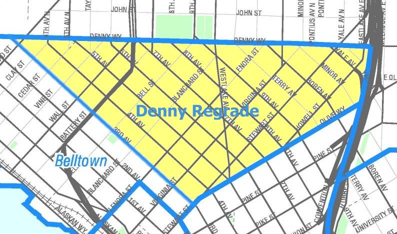
As with most Seattle neighborhoods, the Denny Regrade has no formal borders. The Seattle City Clerk's Neighborhood Map Atlas (which is published by the city but does not have official status as defining neighborhoods) defines the Denny regrade as bounded on the north by Denny Way, on the southwest by Third Avenue, on the southeast by Olive Way, with a small eastern border on Interstate 5.[2] A 2009 map from northwestplaces.com treats the term as synonymous with Belltown and shows both names as referring to a triangle bounded on the north by Denny Way, on the southwest by Western Avenue (two blocks inland of the Central Waterfront), and on the southeast by Stewart Street; the southern tip of this triangle falls in the northern part of Pike Place Market.[3] A map on downtownseattle.com agrees on the northern boundary at Denny Way, but splits this area into "Belltown" and the Denny Triangle and gives both a less regular shape. They divide Belltown to the southwest from the Denny Triangle to the northeast, with the border running mainly along Fifth Avenue but including a small number of properties along Denny Way west of Fifth Avenue as being in the Denny Triangle. They mark the southwest border of Belltown as a block closer to the water (Elliott Avenue) and draw a more ragged southeast border: west of Fifth Avenue, Belltown extends south only to Lenora Street, while east of Fifth Avenue the Denny Triangle is bounded in its westernmost block by Virginia Street and (once it crosses Westlake Avenue) by Olive Way, and with an eastern border on the same small piece of Interstate 5 as the City Clerk's map.[4]
Regrading projects

<templatestyles src="Module:Hatnote/styles.css"></templatestyles>
The Denny Regrade project was the removal of Denny Hill, one of the proverbial seven hills of Seattle. It ran east from First Avenue between Pike Street and Denny Way. Hill and street were named after the Denny family, who were among the city's earliest white inhabitants. The First Avenue regrade was started in 1897 and completed on January 6, 1899. From 1902 to 1911, the hill was sluiced into Elliott Bay by pumping water from Lake Union using hydraulic mining techniques, in a series of regrades along Pike and Pine Streets, Second Avenue, and the massive Denny Regrade No. 1 which regraded everything remaining between Fifth Avenue and the waterfront. In 1929–30, Denny Regrade No. 2 removed the final pieces of the hill east of Fifth Avenue using steam shovels.
Denny Hill

Seattle is located on an isthmus between Lake Washington on the east and Puget Sound on the west. The north-south orientation of the lake and of the city's many hills is the result of glaciation. The terrain was first gouged by south-moving glaciers, and when they retreated, was marked by mounds of rock debris left in their wake. Denny and Queen Anne Hills are two of those north of what is now downtown Seattle.
Photographs
-

Postcard of the 1902–1911 regrade
-

Postcard of the 1902–1911 regrade
-

November 1929 photo of the last regrade, in progress


See also
- Eugene McAllaster, Denny Regrade consulting engineer
- Regrading
References
- ↑ [1]
- ↑ Denny Regrade, map NN-1243L from Seattle City Clerk's Neighborhood Map Atlas.
- ↑ Downtown Map, northwestplaces.com, dated 2009, accessed online 2014-01-12.
- ↑ MID Marketing Neighborhoods Map, Cropped, downtownseattle.com, accessed online 2014-01-12.
External links
| Wikimedia Commons has media related to Denny Regrade, Seattle, Washington. |
- Seattle Daily Journal of Commerce online article: Top Projects of the Century in Washington State: #7, Denny Regrade
- Biography of Eugene L. McAllaster, 1866-1946, Denny Regrade consulting engineer
- Guide to the Seattle Engineering Department Denny Hill Regrade Photograph Album 1904-1929
- Belltown-Denny Regrade -- Thumbnail History
- Seattle Photographs Collection, Denny Regrade - University of Washington
Lua error in package.lua at line 80: module 'strict' not found.