File:Louis's kingdoms and his vassal territories.png
From Infogalactic: the planetary knowledge core

Size of this preview: 800 × 493 pixels. Other resolutions: 320 × 197 pixels | 1,817 × 1,120 pixels.
Original file (1,817 × 1,120 pixels, file size: 3.3 MB, MIME type: image/png)
Summary
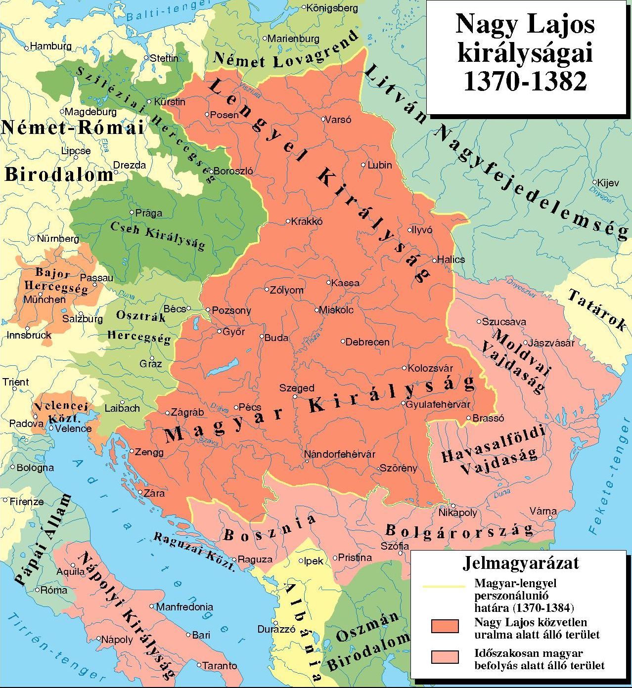
Between 1370-1382 Hungary was in a personal union with Poland (red territories). Louis's vassal (or dependent) territories are coloured coral pink.
- Sources: KNIGHT KINGS,THE ANJOU- AND SIGISMUND AGE IN HUNGARY (1301-1437), Encyclopaedia Humana Hungarica 03.,Budapest, 1997,<a rel="nofollow" class="external autonumber" href="http://mek.oszk.hu/01900/01949/html/cd3a/kepek/historical_geography/tf012cse22.jpg">[1]</a>, + other modern maps (<a rel="nofollow" class="external autonumber" href="http://users2.ml.mindenkilapja.hu/users/vasvarmegyelovagjai/uploads/mo_nlajos.jpg">[2]</a><a rel="nofollow" class="external autonumber" href="http://m.cdn.blog.hu/to/toriblog/image/NLbirodalom.jpg">[3]</a><a rel="nofollow" class="external autonumber" href="http://static.origos.hu/s/img/i/1404/20140429nagy-lajos-i-lajos-magyar4.jpg?w=666&h=627">[4]</a><a rel="nofollow" class="external autonumber" href="http://www.zalatajkiado.hu/online_cikk/zarlatos01.jpg">[5]</a><a rel="nofollow" class="external autonumber" href="http://historical.atlas.verbix.com/a1382eu.gif">[6]</a>)
Licensing
Lua error in package.lua at line 80: module 'strict' not found.
File history
Click on a date/time to view the file as it appeared at that time.
| Date/Time | Thumbnail | Dimensions | User | Comment | |
|---|---|---|---|---|---|
| current | 06:49, 22 December 2016 | | 1,817 × 1,120 (3.3 MB) | 127.0.0.1 (talk) | Between 1370-1382 Hungary was in a personal union with Poland (red territories). Louis's vassal (or dependent) territories are coloured coral pink. <p><br></p> <ul><li>Sources: KNIGHT KINGS,THE ANJOU- AND SIGISMUND AGE IN HUNGARY (1301-1437), Encyclopaedia Humana Hungarica 03.,Budapest, 1997,<a rel="nofollow" class="external autonumber" href="http://mek.oszk.hu/01900/01949/html/cd3a/kepek/historical_geography/tf012cse22.jpg">[1]</a>, + other modern maps (<a rel="nofollow" class="external autonumber" href="http://users2.ml.mindenkilapja.hu/users/vasvarmegyelovagjai/uploads/mo_nlajos.jpg">[2]</a><a rel="nofollow" class="external autonumber" href="http://m.cdn.blog.hu/to/toriblog/image/NLbirodalom.jpg">[3]</a><a rel="nofollow" class="external autonumber" href="http://static.origos.hu/s/img/i/1404/20140429nagy-lajos-i-lajos-magyar4.jpg?w=666&h=627">[4]</a><a rel="nofollow" class="external autonumber" href="http://www.zalatajkiado.hu/online_cikk/zarlatos01.jpg">[5]</a><a rel="nofollow" class="external autonumber" href="http://historical.atlas.verbix.com/a1382eu.gif">[6]</a>)</li></ul> |
- You cannot overwrite this file.
File usage
The following 6 pages link to this file: