Goleta, California
| City of Goleta | ||
|---|---|---|
| General law city[1] | ||

Aerial photo of the Goleta area from offshore.
|
||
|
||
| Nickname(s): The Good Land | ||
 Location in Santa Barbara County and the state of California |
||

City of Goleta
|
||
| Coordinates: Lua error in package.lua at line 80: module 'strict' not found. | ||
| Country | ||
| State | ||
| County | ||
| Incorporated | February 1, 2002[2] | |
| Government | ||
| • Type | Council–Manager[1] | |
| • Mayor | Paula Perotte[3] | |
| • Mayor Pro Tem | Jim Farr[4] | |
| • City council | Roger S. Aceves[5] Michael T. Bennett[6] Tony Vallejo[7] |
|
| • State legislators | Sen. Hannah-Beth Jackson (D) Asm. Das Williams (D) |
|
| • U. S. Rep. | Lois Capps (D)[8] | |
| Area[9] | ||
| • Total | 7.975 sq mi (20.654 km2) | |
| • Land | 7.903 sq mi (20.467 km2) | |
| • Water | 0.072 sq mi (0.187 km2) 0.90% | |
| Elevation[10] | 20 ft (6 m) | |
| Population (April 1, 2010)[11] | ||
| • Total | 29,888 | |
| • Estimate (2013)[11] | 30,525 | |
| • Density | 3,700/sq mi (1,400/km2) | |
| Time zone | Pacific Time Zone (UTC−8) | |
| • Summer (DST) | PDT (UTC−7) | |
| ZIP codes | 93111, 93116–93118, 93160, 93199 | |
| Area code | 805 | |
| FIPS code | 06-30378 | |
| GNIS feature ID | 1660687, 2015546 | |
| Website | www |
|

Goleta (/ɡəˈliːtə/; Spanish: [ɡoˈleta], "schooner"[12]) is a city in southern Santa Barbara County, California, US. It was incorporated as a city in 2002, after a long period as the largest unincorporated, populated area in the county. As of the 2000 census, the Census-designated place (CDP) had a total population of 55,204, however, a significant portion of the census territory of 2000 did not incorporate into the new city. The population was 29,888 at the 2010 census.
It is known for being near the University of California, Santa Barbara campus, although the CDP of Isla Vista is closer to the campus.
Contents
History
Early history
The area of present-day Goleta was populated for thousands of years by the native Chumash people. Locally they became known by the Spanish as Canaliños because they lived along the coast adjacent to the Channel Islands. One of the largest villages, S'axpilil, was north of the Goleta Slough, not far from the present-day Santa Barbara Airport.[13]
The first European visitor to the Goleta area was the Spanish mariner Juan Rodríguez Cabrillo, who spent time around the Channel Islands in 1542, and died there in 1543. During the 1980s, discovery of some 16th-century cannon on the beach led to the advancement of a theory that Sir Francis Drake sailed into the Goleta Slough in 1579. Goleta is one of many alternative locations (and the one farthest south) proposed for Drake's "New Albion" - generally believed to be today's Drake's Bay, north of San Francisco.
In 1602, another sailing expedition, led by Sebastian Vizcaino, visited the California Coast. Vizcaino named the channel "Santa Barbara". Spanish ships associated with the Manila Galleon trade probably stopped in the area intermittently during the next 167 years, but no permanent settlements were established.
The first land expedition to California, led by Gaspar de Portolà, spent several days in the area in 1769, on its way to Monterey Bay, and spent the night of August 20 near a creek (possibly San Pedro Creek) to the north of the Goleta estuary. At that time, the estuary was a very large open-water lagoon that covered most of what is now the city of Goleta, and extended as far north as Lake Los Carneros (adjacent to Stow House).[14] There were at least five native towns in the area, the largest on an island in the middle of the lagoon. For that reason, expedition engineer Miguel Costanso called the group of towns "Pueblos de la Isla".[15] Some of the soldiers called the island town Mescaltitlan, after a similar Aztec island town in Mexico. Franciscan missionary Juan Crespi, who accompanied the expedition, gave the towns the name "Santa Margarita de Cortona".[16]
The island retained the name Mescalitan Island (dropping the extra Aztec "t") until it was bulldozed flat in 1941 to provide fill for the military airfield that is now Goleta airport. The Wastewater Treatment Plant of the Goleta Sanitary District is located on what used to be the island.[17]

Portola returned to San Diego by the same route in January of 1770, and mounted a second expedition to Monterey that year. A second Spanish expedition came to the Santa Barbara area of Alta California in 1774, led by Juan Bautista de Anza. De Anza returned the next year, and the road along the coast of Santa Barbara County (today's Hwy 1) soon became the El Camino Real, connecting the string of Spanish missions.
An expedition in 1782, led by military governor Felipe de Neve, founded the Presidio of Santa Barbara and, soon thereafter, the Santa Barbara Mission. The Goleta area, along with most of the coastal areas of today's Santa Barbara County, was placed in the jurisdiction of the presidio and mission.
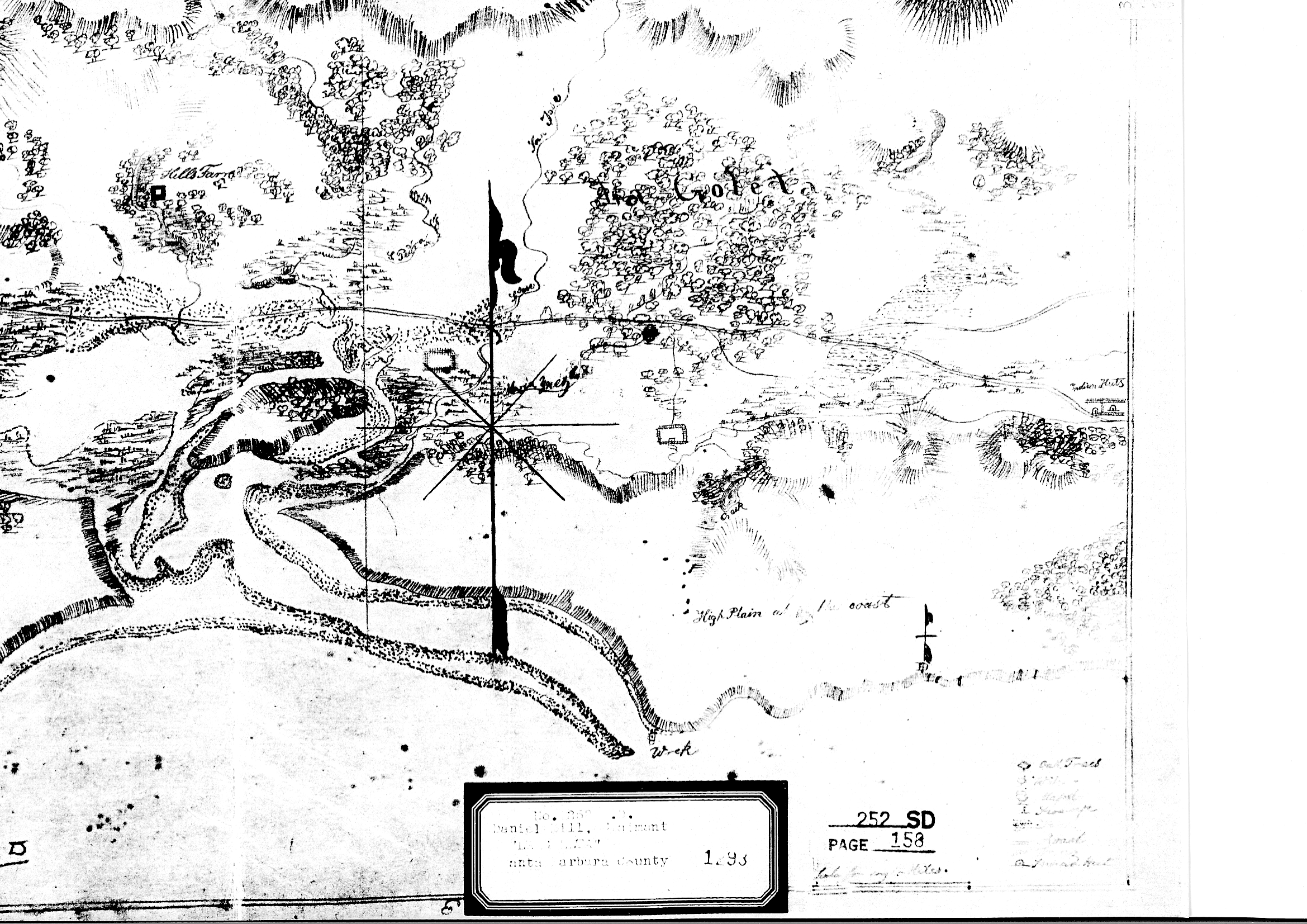
Sometime after the De Anza expeditions, a sailing ship ("goleta") was wrecked at the mouth of the lagoon, and remained visible for many years, giving the area its current name. After Mexico became independent of Spain in 1821, most of the former mission ranch lands were divided up into large grants. The Goleta area became part of two adjacent ranchos. To the east of today's Fairview Avenue was Rancho La Goleta, named for the shipwreck and granted to Daniel A. Hill, the first American resident of Santa Barbara. An 1840s diseño (claim map) of the rancho shows the wrecked ship.[18]
The parts of Goleta to the west of Fairview Avenue were in Rancho Dos Pueblos, granted in 1842 to Nicholas Den, son-in-law of Daniel Hill. Rancho Dos Pueblos included the lagoon, airport, UCSB and Isla Vista, extending to the west as far as the eastern boundary of today's El Capitan State Beach.
19th and 20th centuries
The Goleta Valley was a prominent lemon-growing region during the late 19th and early 20th centuries, and was largely agricultural. Several areas, especially the Ellwood Mesa, were developed for oil and natural gas extraction. In the 1920s, aviation pioneers started using portions of the Goleta Slough that had silted-in due to agriculture to land and takeoff. As former tidelands, the title to these lands was unclear. Starting in 1940, boosters from the city of Santa Barbara lobbied and obtained federal funding and passed a bond measure to formally develop an airport on the Goleta Slough. The necessity for an airport – or at least a military airfield – became more apparent after a Japanese submarine shelled the Ellwood Oil Field in 1942. This was one of the few direct-fire attacks on the US mainland during WW II. The Marine Corps undertook completion of the airport and established Marine Corps Air Station Santa Barbara on the site of the current airport and University of California, Santa Barbara campus.[19]
After the war, Goleta Valley residents supported the construction of Lake Cachuma, which provided water, enabling a housing boom and the establishment of research and aerospace firms in the area. In 1954, the University of California, Santa Barbara moved to part of the former Marine base. Along with the boom in aerospace, the character changed from rural-agricultural to high-tech. Goleta remains a center for high-tech firms, and a bedroom community for neighboring Santa Barbara.
Incorporation
Goleta was incorporated as a city in 2002 after several unsuccessful attempts. A significant urbanized area remains unincorporated between the town of Goleta and the city of Santa Barbara, largely consisting of the area which polled against incorporation prior to the 2002 election (this area was excluded from the city boundaries to facilitate approval of incorporation). There has been some discussion of annexation of this area (sometimes dubbed "Noleta") by the city of Santa Barbara.
In addition, the student community of Isla Vista directly to the south was excluded from the new city of Goleta. Whether or not to include Isla Vista was a subject of debate during incorporation planning, including Goleta residents concerned about impacts on tax revenue and the voting patterns of students.[20] A Local Agency Formation Commission (LAFCO) report supported excluding Isla Vista because of differences in "community identity" but considered both including and excluding Isla Vista to be viable choices.[21]
The 2000 census figures reflect the census-designated place of Goleta, which was somewhat larger than the incorporated city.
The Early 21st Century(2000-2020)
Lua error in package.lua at line 80: module 'strict' not found.
Geography

Goleta is about 8 miles (13 km) west of the city of Santa Barbara, along the coast (the coast runs east to west in this portion of southern California). Nearby is the Santa Barbara campus of the University of California and the student community of Isla Vista.
According to the United States Census Bureau, the CDP has a total area of 26.4 square miles (68 km2), of which 26.3 square miles (68 km2) are land and 0.1 square miles (0.26 km2) (0.38%) is water.
Goleta is a coastal plain in between the Santa Ynez Mountains(the principal mountain range) and the Pacific Ocean. Behind the coastal plain lie foothills, and then the mountains themselves.[22]
The Santa Ynez Mountains form a scenic backdrop to the town, covered by chaparral and displaying prominent sandstone outcrops. The range exceeds 4,000 feet in height to the northwest of Goleta, at Broadcast and Santa Ynez Peaks. Sundowner winds occur in both Goleta and Santa Barbara.
Goleta contains hills, wetlands, bluffs, and pockets of wild land. Most of the wetland is within the Goleta Slough. The bluffs were created by wave erosion along the shoreline, and wild land is most common around bike trails. The land often winds through urban lands.
The bottom of Goleta is the urbanized section, along with suburban neighborhoods. This transitions into agricultural lands farther up from the coast, and eventually blends into wilderness in the foohtills of the Santa Ynez Mountains. Beyond the foothills lie the mountains themselves.
Air quality is good with low ozone concentrations in Goleta, partly because of the lack of heavy industry, and the well-ventilated nature of the air basin. Suburban neighborhoods and small shopping centers make up most of the landscape.
On the Ellwood Mesa, there are some eucalyptus groves where monarch butterflies spend the winter.[23]
Environment
Goleta has a mainly clean, agricultural, suburban environment. A combination of native, feral, and landscaping plants make up most of the landscape. A feral population has spread in Goleta, combining with native and domesticated populations of animals and plants. Small animals are able to thrive within this environment, with a balanced combination of wild habitat and nature, and suburban human resources. Larger animals coming down from the adjacent wild, non-populated lands, such as coyotes, prey on these smaller animals.[24]
Ecology
California is one of the richest and most diverse parts of the world, and includes some of the most endangered ecological communities. It is part of the Nearctic ecozone and spans a number of terrestrial ecoregions.[25]Goleta is just a taste of that vast diversity.
California used to have only native plants and animals, with a few endemic plants and animals, until European contact, which introduced domesticated and feral animals, and non-native plants. Goleta got invaded by invasive European grasses and plants, along with domesticated and a few feral animals.
Climate
Goleta has a mild climate with high temperatures normally within ten degrees of 70° year-round; low temperatures rarely fall below 40°. This climate is called the warm-summer Mediterranean climate. However, Goleta experienced one of the highest temperatures ever recorded in the United States. The city's geography at the base of the Santa Ynez Mountains sometimes subjects Goleta to sudden hot winds locally called "sundowners", similar to the Santa Ana winds in the Los Angeles and San Diego regions. They are caused by high pressure drawing dry air from the inland side of the mountains, whereupon they can become superheated as they rush down on the city's side. On June 17, 1859, a related wind – a superheated simoon –passed through the Goleta and Santa Barbara area, raising the temperature to 133 degrees Fahrenheit (56 degrees Celsius) in minutes. People were forced to take shelter immediately; according to a report of the U.S. Coast Survey, animals died in the fields and fruit dropped from trees.[26] It was the highest temperature recorded in the United States until 1913, when a 134 °F was reached at Death Valley.
Once in every few years, it snows on the mountains. But, the snow rarely stays for more than a few days.
In the winter, monarch butterflies live in several eucalyptus groves on the Ellwood Mesa.[27]
Flora
.jpg)
Many species of plants live in Goleta. For example, the live oak and blue oak are two species of oak. Pine and palm trees also exist. Lemon trees are also common, and Goleta is famous for them. Poison oak and castor bean are two species of poisonous plant that live in Goleta. Chaparral covers nearby hills.
California's native grasses are perennial plants, and some of these inhabit the Goletan hills.[28] After European contact, these were generally replaced by invasive species of European annual grasses; and, in modern times, nearby hills turn a characteristic golden-brown in summer.[29]
Coville's lip fern is native to Goleta.[30]
On the Ellwood Mesa, there are some eucalyptus groves where monarch butterflies spend the winter.[31]
Fauna
<templatestyles src="Module:Hatnote/styles.css"></templatestyles>
Insects

Wasps, the European honeybee, the bumblebee, moths, and flies are among the many insects that live in Goleta. Yellowjacket and honeybee nests are common in Goleta neighborhhods.
Monarch butterflies spend the winter in several eucalyptus groves on the Ellwood Mesa.[32]
Crickets burrow into the ground.
Reptiles
Lizards are common in urbanized areas. Rattlesnakes can be found occasionally near the wild, but are not very common deep in the urbanized areas.
Birds
Barn owls and hawks are common predators. The scrub jay, mourning doves, and woodpeckers are also common.
Marine Life
Sea lions are common off the coast of Goleta, along with orcas, tiger sharks, bull sharks, and great white sharks.[33]
Mammals
Rats, squirrels, opossums, skunks, and the raccoon are common in the neighborhoods, but sightings of bobcats occasionally occur. Red foxes sometimes appear in people's backyards. Coyotes are common in urban areas, and prey on the smaller animals. In the adjoining wildlands, coyotes, bobcats, red foxes, cougars, and American black bears do appear. Deer, sheep, goats, bats, rabbits, hares, gray foxes, weasels, badgers, the ringtail cat, and chipmunks are are also present.
Architecture
The Spanish looks of Santa Barbara sometimes mirror themselves in Goleta.[34] But, the standard style of Goleta is an old, European look.
Urban Environment
Goleta contains a mix of land uses, lacking only heavy industrial zones. North of the US 101 freeway is a region of predominantly tract housing built between the late 1950s and the 1970s, intermingled with newer condominium developments, a few gated communities, and adjacent to a lower-density residential zone in the lower foothills of the Santa Ynez Mountains which contains larger homes. A commercial strip along Calle Real is one of the town's several business districts. South of the freeway is Old Town Goleta, centered on the stretch of Hollister Avenue between Fairview Avenue and the State Route 217 overpass; adjacent to this commercial area is a region of older, and occasionally substandard housing; some of the south county's least affluent people live in this zone. Between Old Town Goleta and the airport, and running along south Fairview Avenue, are some light industrial zones, some of relatively few in southern Santa Barbara County. Farther west, near the intersection of Storke Road and Hollister Avenue, is a large shopping mall, including "big box" stores, which draws business from outside the local area. This area is called the Camino Real Marketplace. There are also several business parks including Cabrillo Business Park, Fairview Business Center and the area along Castilian Drive. Adjacent to the mall and extending more than a mile to the west is a residential area, most of the housing in which dates back to the 1960s; it includes some high-density apartment blocks which accept some of the overflow student population from nearby UCSB. Pockets of wild land are present.
Goleta has several significant parks, including Stow Park, Lake Los Carneros, and the Coronado Butterfly Preserve[35] providing street access to the Ellwood Mesa Open Space[36] on the bluffs overlooking the Pacific Ocean with beach access from UCSB.[37] Goleta Beach County Park is just outside the city limits.[38]

Neighborhoods
Goleta is full of different shops and neighborhoods. Here is a list of all the major sections, along with brief descriptions.
- Old Town Goleta is one of the more heavily populated places in Goleta. It contains shops for vehicle brands like Honda and Toyota. Deeper inside the small section, small restaurants like Taco Bell and Natural Café and stores dot the area.
- The Camino Real Marketplace is a medium-sized shopping center with larger stores, like Costco, Home Depot, and Kmart. Restaurants like McDonalds dot the parking lot around the area. The area is divided into multisections, with Kmart, Ming Dynasty, and Rusty's Pizza on one end and Costco on the other.
- A commercial strip along Calle Real contains a mini-mall with semi-popular stores like CVS, Trader Joes, and Albertsons, along with previously Haggens, which shut down. Small restaurants like Carl's Junior and Subway are mixed throughout the area.
- Just outside city limits, a small shopping center near Hollister Avenue dominated by Ralphs sits close to Turnpike Avenue.
- The section of Hollister Avenue south of Old Town Goleta contains small shops like The Water Store.
- The Santa Barbara Airport is an airport in Santa Barbara, connected to the rest of the city by a strip of land running through the ocean.
- Like the Santa Barbara Airport, Isla Vista is not within city limits, but surrounded by the city. It is a student community, right next to UCSB, the college in Santa Barbara County.
- Goleta Beach and the Goleta Slough are along the coast of Goleta, right next to each other.
- Others include the Cabrillo Business Park and the Fairview Business Center.
- The rest of Goleta is mainly just suburban housing, with a few gated communities. Bike trails wind up all over Goleta.
Geology And Soils
The “Goleta Valley” is a coastal plain between the Santa Ynez Mountains and the ocean, approximately three miles across. It consists of Holocene and Pleistocene alluvium, colluvium, estuarine deposits, as well as marine terraces created during interglacial high sea level episodes. The area has been subject to rapid geologic uplift, as evidenced by its coastal bluffs and narrow beaches.[22] Between the flattest part of the Goleta Valley and the ocean is an area of uplift paralleling the shore which includes, from west to east, Isla Vista, Mescalitan Island, More Mesa, and the Hope Ranch Hills. The elevation of this block of land relative to Goleta Valley increases from 40 to 300 feet along this length.[39][40] The uplift was caused by motion along the More Ranch Fault, one of the most geologically active faults in the area. The More Ranch Fault roughly follows a line along El Colegio Road, through the southern part of the airport, along Atascadero Creek, and then continues east into Santa Barbara as the Mission Ridge Fault Zone.[41] Soils in Goleta are mostly well drained brown fine sandy loam of the Milpitas series.[42]
Underneath the alluvial units of the coastal plain are three prominent bedrock units: the Monterey Formation, the Sisquoc Formation, and the Santa Barbara Formation. This latter unit is the principal groundwater aquifer for the region, and its freshwater wells are protected from seawater intrusion by the uplift along the More Ranch Fault, which has placed relatively impermeable rock units between it and the ocean.[43]
Some of the underlying sedimentary units contain economically recoverable quantities of oil and gas. The Ellwood Oil Field was worked beginning in the 1920s, with its onshore portions only being dismantled in the 1970s. The La Goleta Gas Field was formerly productive on the bluffs west of More Mesa, and is now used for gas storage by the Southern California Gas Company.[44]
The Santa Ynez Mountains form a scenic backdrop to Goleta. They consist of multiple layers of sandstone and conglomerate units dating from the Jurassic Age to the present, uplifted rapidly since the Pliocene. Rapid uplift has given them their craggy, scenic character, and numerous landslides and debris flows, which form some of the urban and suburban lowland area, are testament to their geologically active nature.[40][41]
Economy
The University of California Santa Barbara is the major center of economic activity in the area, both directly and through the numerous associated service industry activities which exist for the staff and students.[citation needed] Hispanic Business has its corporate headquarters in Goleta.[45]
Deckers Outdoor Corporation is based in Goleta. It is the parent company for UGG Australia, Teva, Sanuk, Ahnu and Hoka One One. Several technology sector businesses operate in the area due to the proximity to the university, including Raytheon, Citrix Online, Cisco, FLIR, ATK, InTouch[disambiguation needed], and Transphorm.
The Bacara Resort also employs many residents.
Top employers
As of 2012, the top employers in the city were:[46]
| # | Employer | # of Employees | Employment % to Total Population |
|---|---|---|---|
| 1 | Raytheon | 1,400 | 4.68% |
| 2 | Sansum Clinic | 1,100 | 3.68% |
| 3 | Bacara Resorts | 620 | 2.07% |
| 4 | Goleta Unified School District | 565 | 1.89% |
| 4 | Citrix Online | 544 | 1.82% |
| 5 | Yardi Systems | 445 | 1.49% |
| 6 | FLIR | 425 | 1.42% |
| 7 | Allergan (Inamed) | 352 | 1.18% |
| 8 | Goleta Cottage Hospital | 350 | 1.17% |
| 9 | Karl Storz Imaging | 342 | 1.14% |
| 10 | Medtronic | 250 | 0.84% |
| 11 | Jordano's | 240 | 0.80% |
| 12 | Mentor Corp | 218 | 0.73% |
| 13 | Network Hardware Resale | 210 | 0.70% |
| 14 | Costco | 200 | 0.67% |
| 15 | The Home Depot | 178 | 0.59% |
Demographics
| Historical population | |||
|---|---|---|---|
| Census | Pop. | %± | |
| 2000 | 55,204 | — | |
| 2010 | 29,888 | −45.9% | |
| Est. 2014 | 30,797 | [47] | 3.0% |
|
|
|||
2010
The 2010 United States Census[49] reported that Goleta had a population of 29,888. The population density was 3,747.9 people per square mile (1,447.1/km²). The racial makeup of Goleta was 20,833 (69.7%) White, 469 (1.6%) African American, 283 (0.9%) Native American, 2,728 (9.1%) Asian, 26 (0.1%) Pacific Islander, 4,182 (14.0%) from other races, and 1,367 (4.6%) from two or more races. Hispanic or Latino of any race were 9,824 persons (32.9%).
The Census reported that 29,687 people (99.3% of the population) lived in households, 23 (0.1%) lived in non-institutionalized group quarters, and 178 (0.6%) were institutionalized.
There were 10,903 households, out of which 3,416 (31.3%) had children under the age of 18 living in them, 5,265 (48.3%) were opposite-sex married couples living together, 1,069 (9.8%) had a female householder with no husband present, 472 (4.3%) had a male householder with no wife present. There were 659 (6.0%) unmarried opposite-sex partnerships, and 88 (0.8%) same-sex married couples or partnerships. 2,732 households (25.1%) were made up of individuals and 1,090 (10.0%) had someone living alone who was 65 years of age or older. The average household size was 2.72. There were 6,806 families (62.4% of all households); the average family size was 3.23.
The population was spread out with 6,335 people (21.2%) under the age of 18, 3,790 people (12.7%) aged 18 to 24, 7,966 people (26.7%) aged 25 to 44, 7,749 people (25.9%) aged 45 to 64, and 4,048 people (13.5%) who were 65 years of age or older. The median age was 36.5 years. For every 100 females there were 101.3 males. For every 100 females age 18 and over, there were 100.2 males.
There were 11,473 housing units at an average density of 1,438.7 per square mile (555.5/km²), of which 5,844 (53.6%) were owner-occupied, and 5,059 (46.4%) were occupied by renters. The homeowner vacancy rate was 1.2%; the rental vacancy rate was 4.5%. 16,222 people (54.3% of the population) lived in owner-occupied housing units and 13,465 people (45.1%) lived in rental housing units.
2000
Demographic data for 2000 is for the Goleta CDP, the Goleta Valley area, and not just the half that is the City of Goleta.
As of the census[50] of 2000, there were 55,204 people, 19,954 households, and 13,468 families residing in the CDP. The population density was 2,102.1 people per square mile (811.7/km²). There were 20,442 housing units at an average density of 778.4 per square mile (300.6/km²). The racial makeup of the CDP was 78.61% White, 1.27% African American, 0.82% Native American, 6.43% Asian, 0.11% Pacific Islander, 9.23% from other races, and 3.53% from two or more races. Hispanic or Latino of any race were 22.33% of the population.
There were 19,954 households out of which 30.6% had children under the age of 18 living with them, 55.1% were married couples living together, 8.7% had a female householder with no husband present, and 32.5% were non-families. 22.5% of all households were made up of individuals and 8.8% had someone living alone who was 65 years of age or older. The average household size was 2.72 and the average family size was 3.18.
In the CDP the population was spread out with 23.1% under the age of 18, 9.5% from 18 to 24, 28.6% from 25 to 44, 24.2% from 45 to 64, and 14.6% who were 65 years of age or older. The median age was 38 years. For every 100 females there were 98.4 males. For every 100 females age 18 and over, there were 96.1 males.
The median income for a household in the CDP was $60,314, and the median income for a family was $67,956 (these figures had risen to $69,242 and $81,862 respectively as of a 2007 estimate[51]). Males had a median income of $44,770 versus $32,127 for females. The per capita income for the CDP was $28,890. About 2.9% of families and 6.7% of the population were below the poverty line, including 4.8% of those under age 18 and 4.4% of those age 65 or over.
Education
Most local students attend schools in the Goleta Union School District and the Santa Barbara High School District. There are also a host of smaller private schools.[52]
Schools
Elementary
- Brandon School (within City of Goleta)
- El Camino School
- Ellwood School (within City of Goleta)
- Foothill School
- Hollister School
- Isla Vista School
- Kellogg School (within City of Goleta)
- La Patera School (within City of Goleta)
- Mountain View School[53]
- Goleta Family School[54]
Secondary
Government
The five City Council members take turns as mayor. The City Council also serves as the Planning Agency. City Council, Planning Commission and Design Review Board meetings are televised on the local Government-access television (GATV) channel and available on the City's website.
Transportation
Several Santa Barbara Metropolitan Transit District bus lines run through the city.[56] The main artery of the city is US 101, with the major streets being Hollister Avenue and Cathedral Oaks Road. Other significant streets include Calle Real (which is broken into sections), Storke Road/Glen Annie Road, Los Carneros Road, Fairview Avenue, and Patterson Avenue.[57]
Intercity transit is provided by Amtrak at the Goleta Amtrak Station.
Santa Barbara Airport is adjacent to the City of Goleta, near the intersection of Hollister and South Fairview avenues. The airport serves the greater Santa Barbara area with five airlines connecting to larger hubs.
Major highways
Postal shooting
| Wikinews has related news: Eight dead in Goleta California rampage |
On January 30, 2006, Jennifer San Marco shot and killed seven people, including six postal workers, before committing suicide at the postal-processing facility where she had been previously employed. In addition to Charlotte Colton, 44, and Beverly Graham, 54, the dead included Ze Fairchild, 37, and Maleka Higgins, 28, both of Santa Barbara; Nicola Grant, 42, and Guadalupe Swartz, 52, both of Lompoc; and Dexter Shannon, 57, of Oxnard. This incident is believed to be the deadliest workplace shooting ever carried out in the United States by a woman.[58][59]
Notable people
- Danny Duffy, professional baseball player in MLB, plays for the Kansas City Royals[60]
- Burnett Guffey, Oscar-winning cinematographer
- Lagwagon, a melodic punkband
- Katy Perry, pop singer[61]
- Kim Wilson, blues singer and musician
In Popular Culture
Lua error in package.lua at line 80: module 'strict' not found.
See also
- Santa Barbara, California
- Isla Vista, California
- Goleta Slough
- Campus Point State Marine Conservation Area
- Goleta Depot
- History of Santa Barbara, California
- South Coast Railroad Museum
- Goleta Union School District
- Dos Pueblos High School
References
- ↑ 1.0 1.1 Lua error in package.lua at line 80: module 'strict' not found.
- ↑ Lua error in package.lua at line 80: module 'strict' not found.
- ↑ Lua error in package.lua at line 80: module 'strict' not found.
- ↑ Lua error in package.lua at line 80: module 'strict' not found.
- ↑ Lua error in package.lua at line 80: module 'strict' not found.
- ↑ Lua error in package.lua at line 80: module 'strict' not found.
- ↑ Lua error in package.lua at line 80: module 'strict' not found.
- ↑ Lua error in package.lua at line 80: module 'strict' not found.
- ↑ Lua error in package.lua at line 80: module 'strict' not found.
- ↑ Lua error in package.lua at line 80: module 'strict' not found.
- ↑ 11.0 11.1 Lua error in package.lua at line 80: module 'strict' not found.
- ↑ Lua error in package.lua at line 80: module 'strict' not found.
- ↑ Lua error in package.lua at line 80: module 'strict' not found.
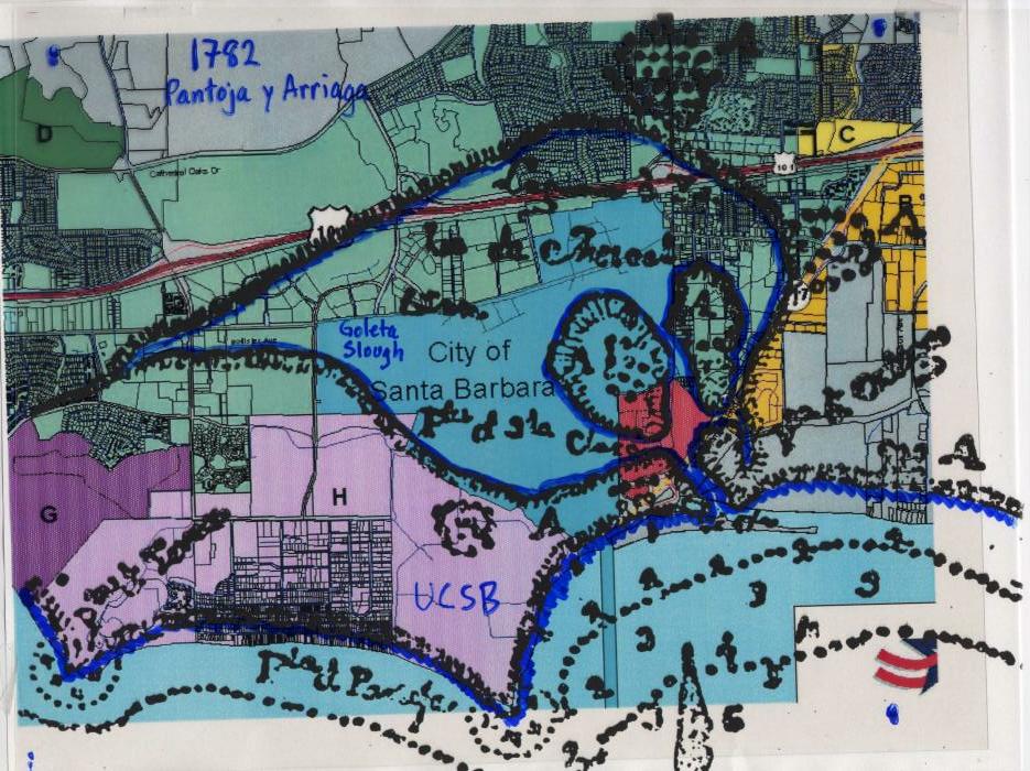
- ↑ A 1782 Spanish map of the lagoon overlaid on a modern map
- ↑ Portola Expedition Diaries
- ↑ Lua error in package.lua at line 80: module 'strict' not found.
- ↑ Goleta Sanitary District
- ↑ Rancho La Goleta diseño
- ↑ Ruhge, Justin (April 1, 2011) "A History of Goleta Valley, California" Goleta Today Goleta Valley Chamber of Commerce
- ↑ Lua error in package.lua at line 80: module 'strict' not found.
- ↑ Lua error in package.lua at line 80: module 'strict' not found.
- ↑ 22.0 22.1 Lua error in package.lua at line 80: module 'strict' not found.
- ↑ "Goleta Butterfly Grove" City of Goleta Accessed 7 February 2015
- ↑ Wolch, West and Gaines Transspecies Urban Theory from Satiety and Space 1995. volume 13, pages 735-760
- ↑ Lua error in package.lua at line 80: module 'strict' not found.
- ↑ Lua error in package.lua at line 80: module 'strict' not found.
- ↑ "Goleta Butterfly Grove" City of Goleta Accessed 7 February 2015
- ↑ Lua error in package.lua at line 80: module 'strict' not found.
- ↑ Lua error in package.lua at line 80: module 'strict' not found.
- ↑ USDA: Cheilanthes covillei
- ↑ "Goleta Butterfly Grove" City of Goleta Accessed 7 February 2015
- ↑ "Goleta Butterfly Grove" City of Goleta Accessed 7 February 2015
- ↑ http://www.sharkresearchcommittee.com/indigenous.htm
- ↑ http://www.tripadvisor.com/Travel-g33045-s201/Santa-Barbara:California:Architecture.html
- ↑ http://www.sblandtrust.org/coronado.html Coronado Butterfly Preserve
- ↑ City of Goleta - Ellwood Mesa Open Space http://www.cityofgoleta.org/index.aspx?page=320
- ↑ UCSB Ellwood Open Space and Habitat Management Plan http://www.ucsbvision2025.com/pdfs/EIR/4.3_Biology.pdf
- ↑ Lua error in package.lua at line 80: module 'strict' not found.
- ↑ Norris, p. 101
- ↑ 40.0 40.1 http://ngmdb.usgs.gov/ngm-bin/pdp/zui_viewer.pl?id=26031Dibblee, T.W., and Ehrenspeck, H.E., ed., 1986, Geologic map of the Santa Barbara quadrangle, Santa Barbara County, California: Dibblee Geological Foundation, Dibblee Foundation Map DF-06, scale 1:24,000
- ↑ 41.0 41.1 Lua error in package.lua at line 80: module 'strict' not found.
- ↑ http://casoilresource.lawr.ucdavis.edu/gmap/
- ↑ Norris, p. 95, 101
- ↑ Lua error in package.lua at line 80: module 'strict' not found.
- ↑ "Contact Us." Hispanic Business. Retrieved on February 7, 2012. "Hispanic Business Inc. 475 Pine Avenue Santa Barbara, CA 93117-3709"
- ↑ Lua error in package.lua at line 80: module 'strict' not found.
- ↑ Lua error in package.lua at line 80: module 'strict' not found.
- ↑ Lua error in package.lua at line 80: module 'strict' not found.
- ↑ Lua error in package.lua at line 80: module 'strict' not found.
- ↑ Lua error in package.lua at line 80: module 'strict' not found.
- ↑ US Census Fact Sheet for Goleta
- ↑ Lua error in package.lua at line 80: module 'strict' not found.
- ↑ Lua error in package.lua at line 80: module 'strict' not found.
- ↑ Lua error in package.lua at line 80: module 'strict' not found.
- ↑ Lua error in package.lua at line 80: module 'strict' not found.
- ↑ Lua error in package.lua at line 80: module 'strict' not found.
- ↑ Lua error in package.lua at line 80: module 'strict' not found.
- ↑ Lua error in package.lua at line 80: module 'strict' not found.
- ↑ Lua error in package.lua at line 80: module 'strict' not found.
- ↑ Lua error in package.lua at line 80: module 'strict' not found.
- ↑ Lua error in package.lua at line 80: module 'strict' not found.
External links
| Wikimedia Commons has media related to Goleta, California. |
| Wikivoyage has a travel guide for [[Wikivoyage:Goleta#Lua error in Module:Wikidata at line 863: attempt to index field 'wikibase' (a nil value).|Goleta]]. |
- No URL found. Please specify a URL here or add one to Wikidata.
- City map showing current boundaries
- City of Goleta's Capital Improvement Project website
- City of Goleta's San Jose Creek Project website
- City of Goleta's Monarch Butterfly Grove website
- Goleta Chamber Of Commerce website
- Goleta Union School District website
- Movies and televisions shows filmed in Goleta
|
Municipalities and communities of Santa Barbara County, California, United States
|
||
|---|---|---|
| Cities |
 |
|
| CDPs | ||
| Unincorporated communities |
||
| Indian reservation |
||
| Ghost towns | ||
- Use mdy dates from October 2014
- Articles using small message boxes
- Articles with unsourced statements from February 2012
- All articles with links needing disambiguation
- Articles with links needing disambiguation from January 2012
- Commons category link is defined as the pagename
- Official website missing URL
- Goleta, California
- Cities in Santa Barbara County, California
- Incorporated cities and towns in California
- Populated coastal places in California
- Former census-designated places in California
- 2002 establishments in California
- Populated places established in 2002