Kharkiv Metro
| 275px
The central platform of one of the first stations in the system, Kholodna Hora.
|
|||
| Overview | |||
|---|---|---|---|
| Native name | Харківський метрополітен Kharkivskyi metropoliten |
||
| Owner | City of Kharkiv | ||
| Locale | Kharkiv, Ukraine | ||
| Transit type | Metro/Subway | ||
| Number of lines | 3[1] | ||
| Number of stations | 29[1] | ||
| Daily ridership | 633,150 (2013) | ||
| Annual ridership | 231.1 million (2013)[1] | ||
| Website | Kharkiv Metro (Ukrainian) | ||
| Operation | |||
| Began operation | 1975 | ||
| Number of vehicles | 59 | ||
| Train length | 5 cars | ||
| Technical | |||
| System length | 37.6 km (23.4 mi)[1] | ||
|
|||
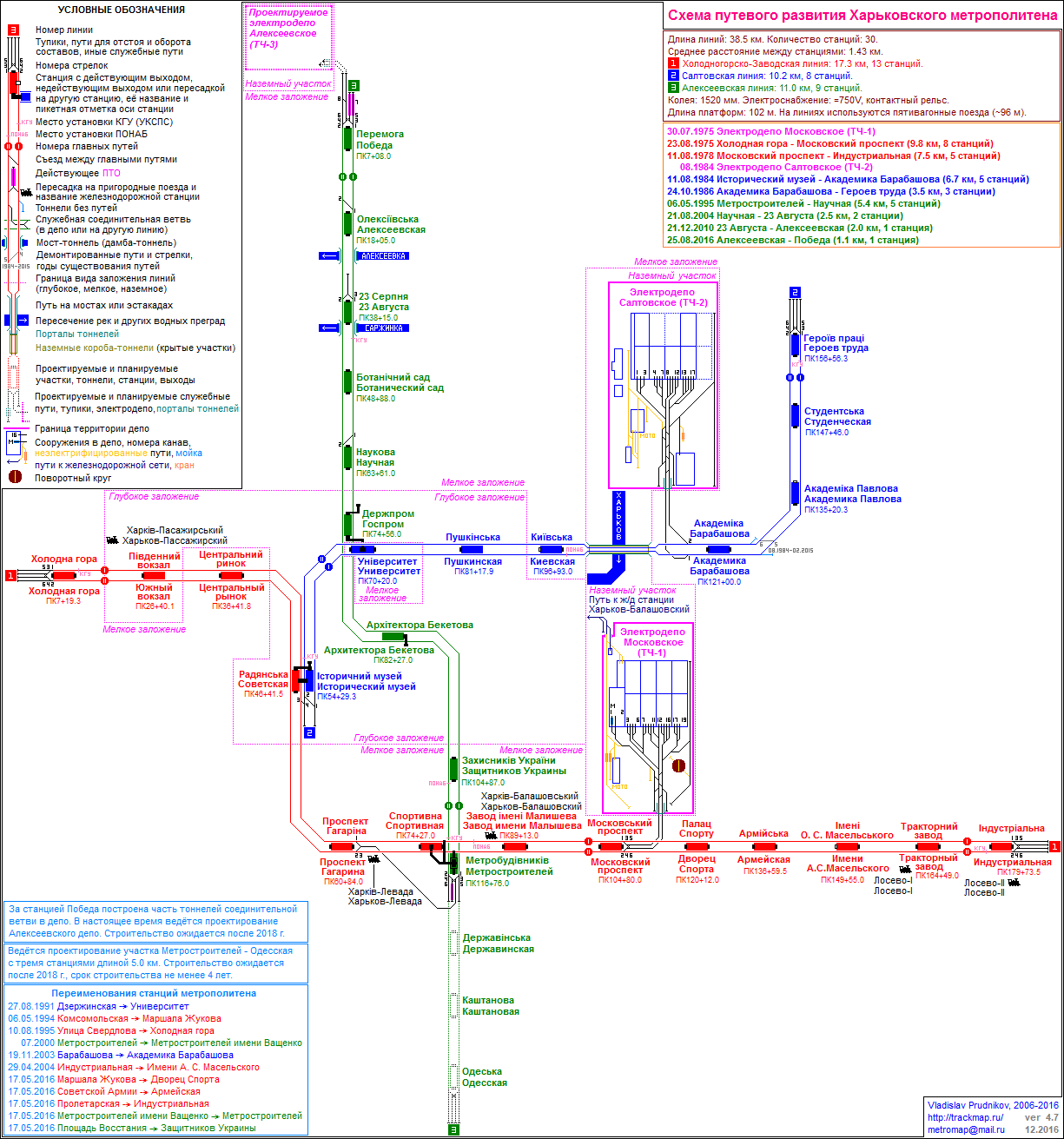
The Kharkiv Metro (Ukrainian: Харківське метро or Харківський метрополітен) is the metro system that serves the city of Kharkiv, the second largest city in Ukraine. The metro was the second in Ukraine (after Kiev) and the sixth in the USSR when it opened in 1975. The metro consists of three lines which operate on 37.6 kilometres (23.4 mi) of route and serve 29 stations.[1] The system transported 231.1 million passengers in 2013[1] (down from 239.3 million in 2012[2]).
Contents
History
Initial plans for a rapid transit system in Kharkiv were made when the city was a capital of the Ukrainian Soviet Socialist Republic. However, after the capital moved to Kiev in 1934 and Kharkiv suffered heavy destruction during World War II, a rapid transit system was dropped from the agenda. In the mid-1960s, the existing mass transit system became too strained, and construction of the metro began in 1968.
Seven years later on August 23, 1975, the first eight-station segment of 10.4 kilometres (6.5 mi) was put into use. It is claimed that the metro does not have the beautiful and excessive decorations that stations in Moscow and Saint Petersburg[citation needed] Metros show, yet they do make the best of mid-1970s and later styles.
Lines and stations
<templatestyles src="Module:Hatnote/styles.css"></templatestyles>
| # | Name | Opened | Length | Stations |
|---|---|---|---|---|
| 1 | Kholodnohirsko-Zavodska Line | 1975 | 17.3 km[citation needed] | 13 |
| 2 | Saltivska Line | 1984 | 10.4 km[citation needed] | 8 |
| 3 | Oleksiivska Line | 1995 | 11.9 km[citation needed] | 8 |
| TOTAL: | 39.6 km[citation needed] | 29 | ||
Facts and numbers

Currently, the Kharkiv Metro consists of 3 lines, 29 stations, and 37.6 kilometres (23.4 mi) of route.[1] The stations arranged in a typical Soviet design of a triangle, that is, three radial lines crossing in the city centre. Open from 5:30 in the morning until midnight, it has a daily passenger traffic of over one million passengers.
Because of the city's uneven landscape, the metro stations are located on varying depths. Six of the system's 29 stations are deep level stations and the remaining rest are shallow. Of the former, all but one are pylon type, and the latter are of column type. The shallow stations comprise fourteen pillar-trispans and eight single vaults. Kharkiv was the first metro to exhibit the single vault design of the shallow type (see more at the Skhodnenskaya article).
The metro is served by two depots which have a total of 320 carriages forming 59 five-car trainsets[citation needed] (all of the platforms are exactly 100 metres (330 ft) long).
The metro is directly subordinated to the Ministry of Transport of Ukraine. Unlike the Kiev Metro, Kharkiv is not privatised and owned by a municipal company. In 2009, the Ministry transferred the metro to the city administration.
In preparation for the Euro 2012 football championship, the metro announced that it would be installing bilingual announcements in Ukrainian and English for its trains, planned to begin operation by April 2012 despite the fact that most of the city's population only speaks Russian.[3]
See also
References
External links
| Wikimedia Commons has media related to Kharkiv Metro. |
- Kharkiv Metro – official site (Ukrainian)
- Kharkiv Metro – unofficial website (Russian)
- Kharkiv Metro track map
- Kharkiv Metro at UrbanRail.net
- Kharkiv Metro at Subways.net
- Metro soyuza – Photographs (German)/(Russian)
- Kharkiv Transportny – Popular site with resources and images (Russian)
- Photos of Kharkiv Metro — on virtual photo gallery Metro (Russian)/(Ukrainian)
|
Kharkiv Metro
|
||
|---|---|---|
| Kholodnohirsko–Zavodska Line |
|
|
| Saltivska Line |
||
| Oleksiivska Line |
||
- Pages with broken file links
- Articles with Ukrainian-language external links
- Articles containing Ukrainian-language text
- Articles with unsourced statements from May 2008
- Articles with unsourced statements from May 2013
- Articles with unsourced statements from May 2014
- Commons category link is defined as the pagename
- Articles with Russian-language external links
- Articles with German-language external links
- Kharkiv Metro
- Underground rapid transit in Ukraine