South East Cape
| South East Cape | |
| Cape | |
|
1916 map of the south coast of Tasmania, showing South East Cape
|
|
| Country | Australia |
|---|---|
| State | Tasmania |
| Region | South Coast |
| Location | South Coast |
| - coordinates | Lua error in package.lua at line 80: module 'strict' not found. |
| Easiest access | South Coast Track |
| UNESCO World Heritage Site | |
| Name | Tasmanian Wilderness |
| Year | 1982 (#6) |
| Number | 181 |
| Region | Oceania |
| Criteria | Mixed |
| National park | Southwest NP |
 Location of South East Cape in Tasmania
|
|
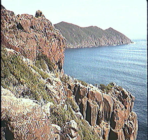
The South East Cape is a cape located at the southernmost point of the main island of Tasmania, the southernmost state of Australia.[1] The cape is situated in the southern and south-eastern corner of the Southwest National Park, part of the Tasmanian Wilderness World Heritage Area, approximately 94 kilometres (58 mi) southwest of Hobart in Tasmania, and about 65 kilometres (40 mi) east and a little south of the South West Cape.
Location and features
The Islands of the Maatsuyker and Pedra Branca island groups, as well as the subantarctic Macquarie Island, lie further south than the South East Cape and are also part of the state of Tasmania.
South East Cape is one of the Five Southernmost Capes that can be rounded by Southern Ocean sailors.
The cape is also a reference point for sectors of the southern coastline of Tasmania.[2] It is also the location of boating mishaps [3]
See also
<templatestyles src="Stack/styles.css"/>
References
External links
- Continental Extremities of Australia
- Picture of South East Cape
- Map of the area with South East Cape on the right edge, South Cape, South West Cape, the Maatsuyker Islands with De Witt Island, The Sisters and Maatsuyker Island
- Another map of the area between South East Cape and South West Cape and the Maatsuyker Islands
<templatestyles src="Asbox/styles.css"></templatestyles>
|
This Tasmania geography article is a stub. You can help Wikipedia by expanding it. |